You are here: Home > Network List > NW - Northwestern University Seismic Network Stations List
> Station L44A Ryerson Woods, Lake Cnty Forest Preserve, IL, USA > Earthquake Result Viewer
L44A Ryerson Woods, Lake Cnty Forest Preserve, IL, USA - Earthquake Result Viewer
| Earthquake location: |
San Juan Province, Argentina |
| Earthquake latitude/longitude: |
-31.8/-68.8 |
| Earthquake time(UTC): |
2021/01/19 (019) 02:46:22 GMT |
| Earthquake Depth: |
20 km |
| Earthquake Magnitude: |
6.4 mww |
| Earthquake Catalog/Contributor: |
NEIC PDE/us |
|
| Network: |
NW Northwestern University Seismic Network |
| Station: |
L44A Ryerson Woods, Lake Cnty Forest Preserve, IL, USA |
| Lat/Lon: |
42.18 N/87.91 W |
| Elevation: |
202 m |
|
| Distance: |
75.7 deg |
| Az: |
345.49 deg |
| Baz: |
163.324 deg |
| Ray Param: |
0.05148365 |
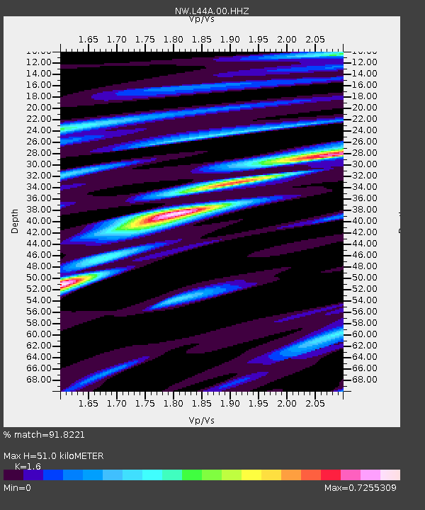
| Estimated Moho Depth: |
51.0 km |
| Estimated Crust Vp/Vs: |
1.60 |
| Assumed Crust Vp: |
6.483 km/s |
| Estimated Crust Vs: |
4.052 km/s |
| Estimated Crust Poisson's Ratio: |
0.18 |
|
| Radial Match: |
91.8221 % |
| Radial Bump: |
323 |
| Transverse Match: |
75.11511 % |
| Transverse Bump: |
400 |
| SOD ConfigId: |
23341671 |
| Insert Time: |
2021-02-02 04:01:54.127 +0000 |
| GWidth: |
2.5 |
| Max Bumps: |
400 |
| Tol: |
0.001 |
|

Signal To Noise
| Channel | StoN | STA | LTA |
| NW:L44A:00:HHZ:20210119T02:57:35.010023Z | 5.000152 | 1.7999788E-6 | 3.599848E-7 |
| NW:L44A:00:HH1:20210119T02:57:35.010023Z | 3.6444843 | 1.0207152E-6 | 2.8007122E-7 |
| NW:L44A:00:HH2:20210119T02:57:35.010023Z | 1.4840184 | 4.7287324E-7 | 3.1864377E-7 |
| Arrivals |
| Ps | 4.9 SECOND |
| PpPs | 20 SECOND |
| PsPs/PpSs | 25 SECOND |


