You are here: Home > Network List > O2 - Oklahoma Consolidated Temporary Seismic Networks Stations List
> Station DRUM Drumwright, Oklahoma, USA > Earthquake Result Viewer
DRUM Drumwright, Oklahoma, USA - Earthquake Result Viewer
| Earthquake location: |
San Juan Province, Argentina |
| Earthquake latitude/longitude: |
-31.8/-68.8 |
| Earthquake time(UTC): |
2021/01/19 (019) 02:46:22 GMT |
| Earthquake Depth: |
20 km |
| Earthquake Magnitude: |
6.4 mww |
| Earthquake Catalog/Contributor: |
NEIC PDE/us |
|
| Network: |
O2 Oklahoma Consolidated Temporary Seismic Networks |
| Station: |
DRUM Drumwright, Oklahoma, USA |
| Lat/Lon: |
35.92 N/96.61 W |
| Elevation: |
296 m |
|
| Distance: |
72.2 deg |
| Az: |
336.611 deg |
| Baz: |
155.397 deg |
| Ray Param: |
0.05377752 |
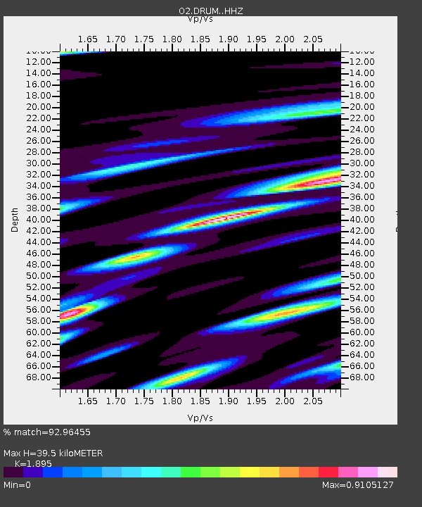
| Estimated Moho Depth: |
39.5 km |
| Estimated Crust Vp/Vs: |
1.89 |
| Assumed Crust Vp: |
6.426 km/s |
| Estimated Crust Vs: |
3.391 km/s |
| Estimated Crust Poisson's Ratio: |
0.31 |
|
| Radial Match: |
92.96455 % |
| Radial Bump: |
328 |
| Transverse Match: |
77.90643 % |
| Transverse Bump: |
400 |
| SOD ConfigId: |
23341671 |
| Insert Time: |
2021-02-02 04:02:14.331 +0000 |
| GWidth: |
2.5 |
| Max Bumps: |
400 |
| Tol: |
0.001 |
|

Signal To Noise
| Channel | StoN | STA | LTA |
| O2:DRUM: :HHZ:20210119T02:57:14.844984Z | 10.893861 | 2.03956E-6 | 1.8722106E-7 |
| O2:DRUM: :HHN:20210119T02:57:14.844984Z | 2.9819956 | 7.473709E-7 | 2.5062778E-7 |
| O2:DRUM: :HHE:20210119T02:57:14.844984Z | 2.2013514 | 5.391283E-7 | 2.4490785E-7 |
| Arrivals |
| Ps | 5.7 SECOND |
| PpPs | 17 SECOND |
| PsPs/PpSs | 23 SECOND |


