You are here: Home > Network List > O2 - Oklahoma Consolidated Temporary Seismic Networks Stations List
> Station ROSS Rosston, Oklahoma, USA > Earthquake Result Viewer
ROSS Rosston, Oklahoma, USA - Earthquake Result Viewer
| Earthquake location: |
San Juan Province, Argentina |
| Earthquake latitude/longitude: |
-31.8/-68.8 |
| Earthquake time(UTC): |
2021/01/19 (019) 02:46:22 GMT |
| Earthquake Depth: |
20 km |
| Earthquake Magnitude: |
6.4 mww |
| Earthquake Catalog/Contributor: |
NEIC PDE/us |
|
| Network: |
O2 Oklahoma Consolidated Temporary Seismic Networks |
| Station: |
ROSS Rosston, Oklahoma, USA |
| Lat/Lon: |
36.95 N/99.87 W |
| Elevation: |
607 m |
|
| Distance: |
74.3 deg |
| Az: |
334.607 deg |
| Baz: |
152.891 deg |
| Ray Param: |
0.052413724 |
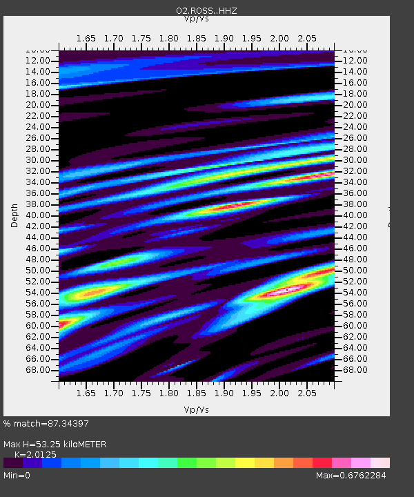
| Estimated Moho Depth: |
53.25 km |
| Estimated Crust Vp/Vs: |
2.01 |
| Assumed Crust Vp: |
6.426 km/s |
| Estimated Crust Vs: |
3.193 km/s |
| Estimated Crust Poisson's Ratio: |
0.34 |
|
| Radial Match: |
87.34397 % |
| Radial Bump: |
400 |
| Transverse Match: |
67.076096 % |
| Transverse Bump: |
400 |
| SOD ConfigId: |
23341671 |
| Insert Time: |
2021-02-02 04:03:05.579 +0000 |
| GWidth: |
2.5 |
| Max Bumps: |
400 |
| Tol: |
0.001 |
|

Signal To Noise
| Channel | StoN | STA | LTA |
| O2:ROSS: :HHZ:20210119T02:57:27.029982Z | 7.9055777 | 1.4380691E-6 | 1.8190563E-7 |
| O2:ROSS: :HHN:20210119T02:57:27.029982Z | 1.6291969 | 5.458871E-7 | 3.3506515E-7 |
| O2:ROSS: :HHE:20210119T02:57:27.029982Z | 1.2460558 | 3.6762736E-7 | 2.9503283E-7 |
| Arrivals |
| Ps | 8.6 SECOND |
| PpPs | 24 SECOND |
| PsPs/PpSs | 33 SECOND |


