You are here: Home > Network List > O2 - Oklahoma Consolidated Temporary Seismic Networks Stations List
> Station SC13 Stratford, Oklahoma, USA > Earthquake Result Viewer
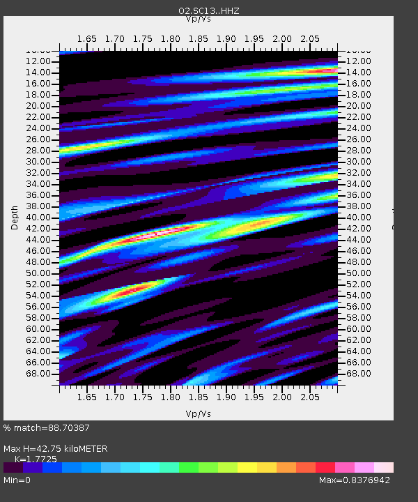
SC13 Stratford, Oklahoma, USA - Earthquake Result Viewer
| Earthquake location: |
San Juan Province, Argentina |
| Earthquake latitude/longitude: |
-31.8/-68.8 |
| Earthquake time(UTC): |
2021/01/19 (019) 02:46:22 GMT |
| Earthquake Depth: |
20 km |
| Earthquake Magnitude: |
6.4 mww |
| Earthquake Catalog/Contributor: |
NEIC PDE/us |
|
| Network: |
O2 Oklahoma Consolidated Temporary Seismic Networks |
| Station: |
SC13 Stratford, Oklahoma, USA |
| Lat/Lon: |
34.73 N/96.95 W |
| Elevation: |
363 m |
|
| Distance: |
71.3 deg |
| Az: |
335.82 deg |
| Baz: |
154.953 deg |
| Ray Param: |
0.054418642 |
| Estimated Moho Depth: |
42.75 km |
| Estimated Crust Vp/Vs: |
1.77 |
| Assumed Crust Vp: |
6.426 km/s |
| Estimated Crust Vs: |
3.625 km/s |
| Estimated Crust Poisson's Ratio: |
0.27 |
|
| Radial Match: |
88.70387 % |
| Radial Bump: |
334 |
| Transverse Match: |
77.53542 % |
| Transverse Bump: |
400 |
| SOD ConfigId: |
23341671 |
| Insert Time: |
2021-02-02 04:03:29.275 +0000 |
| GWidth: |
2.5 |
| Max Bumps: |
400 |
| Tol: |
0.001 |
|

Signal To Noise
| Channel | StoN | STA | LTA |
| O2:SC13: :HHZ:20210119T02:57:09.075026Z | 12.971428 | 1.942913E-6 | 1.4978407E-7 |
| O2:SC13: :HHN:20210119T02:57:09.075026Z | 3.5641599 | 8.8893563E-7 | 2.494096E-7 |
| O2:SC13: :HHE:20210119T02:57:09.075026Z | 2.2443335 | 2.7707338E-7 | 1.2345464E-7 |
| Arrivals |
| Ps | 5.3 SECOND |
| PpPs | 18 SECOND |
| PsPs/PpSs | 23 SECOND |


