You are here: Home > Network List > O2 - Oklahoma Consolidated Temporary Seismic Networks Stations List
> Station SMNL Seminole, Oklahoma, USA > Earthquake Result Viewer
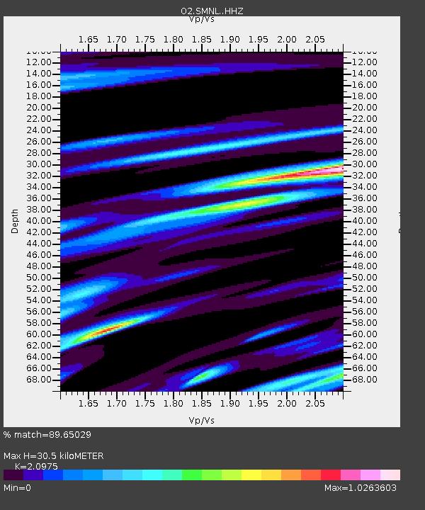
SMNL Seminole, Oklahoma, USA - Earthquake Result Viewer
| Earthquake location: |
San Juan Province, Argentina |
| Earthquake latitude/longitude: |
-31.8/-68.8 |
| Earthquake time(UTC): |
2021/01/19 (019) 02:46:22 GMT |
| Earthquake Depth: |
20 km |
| Earthquake Magnitude: |
6.4 mww |
| Earthquake Catalog/Contributor: |
NEIC PDE/us |
|
| Network: |
O2 Oklahoma Consolidated Temporary Seismic Networks |
| Station: |
SMNL Seminole, Oklahoma, USA |
| Lat/Lon: |
35.29 N/96.56 W |
| Elevation: |
317 m |
|
| Distance: |
71.7 deg |
| Az: |
336.369 deg |
| Baz: |
155.345 deg |
| Ray Param: |
0.054172825 |
| Estimated Moho Depth: |
30.5 km |
| Estimated Crust Vp/Vs: |
2.10 |
| Assumed Crust Vp: |
6.426 km/s |
| Estimated Crust Vs: |
3.064 km/s |
| Estimated Crust Poisson's Ratio: |
0.35 |
|
| Radial Match: |
89.65029 % |
| Radial Bump: |
380 |
| Transverse Match: |
72.15456 % |
| Transverse Bump: |
400 |
| SOD ConfigId: |
23341671 |
| Insert Time: |
2021-02-02 04:03:40.914 +0000 |
| GWidth: |
2.5 |
| Max Bumps: |
400 |
| Tol: |
0.001 |
|

Signal To Noise
| Channel | StoN | STA | LTA |
| O2:SMNL: :HHZ:20210119T02:57:11.370009Z | 5.1547375 | 1.3953862E-6 | 2.7069976E-7 |
| O2:SMNL: :HHN:20210119T02:57:11.370009Z | 0.9703719 | 3.524882E-7 | 3.6325062E-7 |
| O2:SMNL: :HHE:20210119T02:57:11.370009Z | 1.5594578 | 4.5774192E-7 | 2.9352634E-7 |
| Arrivals |
| Ps | 5.4 SECOND |
| PpPs | 14 SECOND |
| PsPs/PpSs | 20 SECOND |


