You are here: Home > Network List > PE - Penn State Network Stations List
> Station PAMR Moraine State Park, Slippery Rock, PA > Earthquake Result Viewer
PAMR Moraine State Park, Slippery Rock, PA - Earthquake Result Viewer
| Earthquake location: |
San Juan Province, Argentina |
| Earthquake latitude/longitude: |
-31.8/-68.8 |
| Earthquake time(UTC): |
2021/01/19 (019) 02:46:22 GMT |
| Earthquake Depth: |
20 km |
| Earthquake Magnitude: |
6.4 mww |
| Earthquake Catalog/Contributor: |
NEIC PDE/us |
|
| Network: |
PE Penn State Network |
| Station: |
PAMR Moraine State Park, Slippery Rock, PA |
| Lat/Lon: |
40.94 N/80.10 W |
| Elevation: |
393 m |
|
| Distance: |
73.1 deg |
| Az: |
351.116 deg |
| Baz: |
170.006 deg |
| Ray Param: |
0.053186066 |
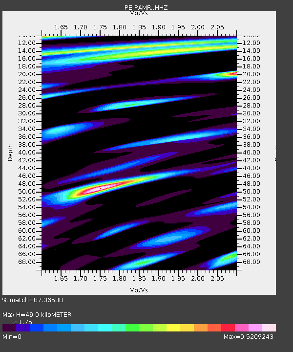
| Estimated Moho Depth: |
49.0 km |
| Estimated Crust Vp/Vs: |
1.75 |
| Assumed Crust Vp: |
6.483 km/s |
| Estimated Crust Vs: |
3.704 km/s |
| Estimated Crust Poisson's Ratio: |
0.26 |
|
| Radial Match: |
87.36538 % |
| Radial Bump: |
400 |
| Transverse Match: |
57.320694 % |
| Transverse Bump: |
400 |
| SOD ConfigId: |
23341671 |
| Insert Time: |
2021-02-02 04:05:24.403 +0000 |
| GWidth: |
2.5 |
| Max Bumps: |
400 |
| Tol: |
0.001 |
|

Signal To Noise
| Channel | StoN | STA | LTA |
| PE:PAMR: :HHZ:20210119T02:57:20.180006Z | 3.2500596 | 1.6362907E-6 | 5.034648E-7 |
| PE:PAMR: :HHN:20210119T02:57:20.180006Z | 2.081787 | 7.6509843E-7 | 3.6752002E-7 |
| PE:PAMR: :HHE:20210119T02:57:20.180006Z | 0.7714887 | 3.0853016E-7 | 3.9991534E-7 |
| Arrivals |
| Ps | 5.9 SECOND |
| PpPs | 20 SECOND |
| PsPs/PpSs | 26 SECOND |


