You are here: Home > Network List > TX - Texas Seismological Network Stations List
> Station FW07 Weatherford > Earthquake Result Viewer
FW07 Weatherford - Earthquake Result Viewer
| Earthquake location: |
San Juan Province, Argentina |
| Earthquake latitude/longitude: |
-31.8/-68.8 |
| Earthquake time(UTC): |
2021/01/19 (019) 02:46:22 GMT |
| Earthquake Depth: |
20 km |
| Earthquake Magnitude: |
6.4 mww |
| Earthquake Catalog/Contributor: |
NEIC PDE/us |
|
| Network: |
TX Texas Seismological Network |
| Station: |
FW07 Weatherford |
| Lat/Lon: |
32.70 N/97.79 W |
| Elevation: |
311 m |
|
| Distance: |
69.8 deg |
| Az: |
334.225 deg |
| Baz: |
153.957 deg |
| Ray Param: |
0.055415764 |
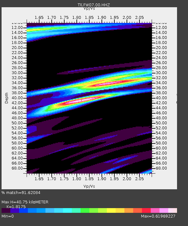
| Estimated Moho Depth: |
40.75 km |
| Estimated Crust Vp/Vs: |
1.82 |
| Assumed Crust Vp: |
6.38 km/s |
| Estimated Crust Vs: |
3.511 km/s |
| Estimated Crust Poisson's Ratio: |
0.28 |
|
| Radial Match: |
91.62084 % |
| Radial Bump: |
334 |
| Transverse Match: |
70.827034 % |
| Transverse Bump: |
400 |
| SOD ConfigId: |
23341671 |
| Insert Time: |
2021-02-02 04:08:22.418 +0000 |
| GWidth: |
2.5 |
| Max Bumps: |
400 |
| Tol: |
0.001 |
|

Signal To Noise
| Channel | StoN | STA | LTA |
| TX:FW07:00:HHZ:20210119T02:56:59.82997Z | 8.183715 | 1.3265465E-6 | 1.6209587E-7 |
| TX:FW07:00:HH1:20210119T02:56:59.82997Z | 4.193524 | 7.390203E-7 | 1.7622894E-7 |
| TX:FW07:00:HH2:20210119T02:56:59.82997Z | 1.0723928 | 2.563887E-7 | 2.3908095E-7 |
| Arrivals |
| Ps | 5.4 SECOND |
| PpPs | 17 SECOND |
| PsPs/PpSs | 23 SECOND |


