You are here: Home > Network List > GE - GEOFON Stations List
> Station MTE GEOFON Station Manteigas, Portugal > Earthquake Result Viewer
MTE GEOFON Station Manteigas, Portugal - Earthquake Result Viewer
| Earthquake location: |
South Sandwich Islands Region |
| Earthquake latitude/longitude: |
-55.6/-29.9 |
| Earthquake time(UTC): |
2000/11/07 (312) 00:18:04 GMT |
| Earthquake Depth: |
10 km |
| Earthquake Magnitude: |
6.7 MS, 6.8 MW, 6.6 MW |
| Earthquake Catalog/Contributor: |
WHDF/NEIC |
|
| Network: |
GE GEOFON |
| Station: |
MTE GEOFON Station Manteigas, Portugal |
| Lat/Lon: |
40.40 N/7.54 W |
| Elevation: |
815 m |
|
| Distance: |
97.5 deg |
| Az: |
17.02 deg |
| Baz: |
192.555 deg |
| Ray Param: |
0.040186174 |
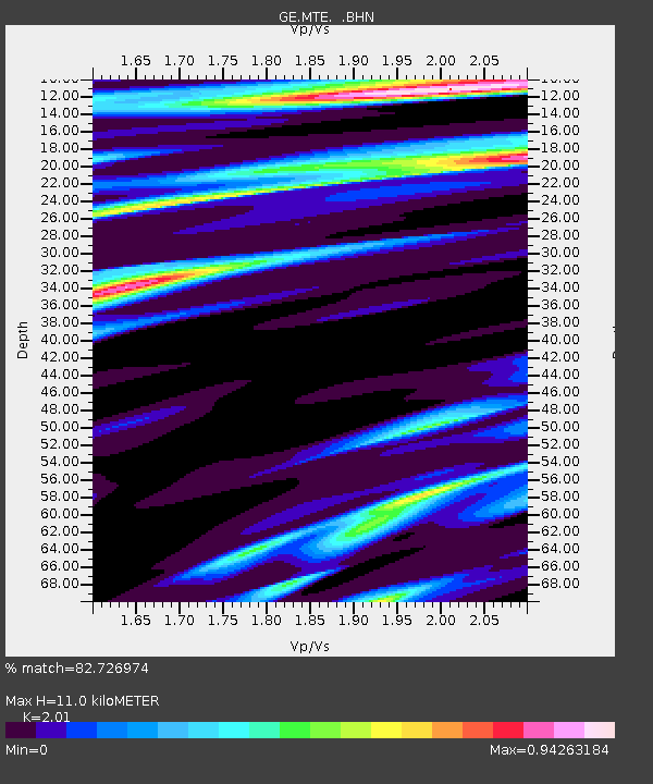
| Estimated Moho Depth: |
11.0 km |
| Estimated Crust Vp/Vs: |
2.01 |
| Assumed Crust Vp: |
6.276 km/s |
| Estimated Crust Vs: |
3.122 km/s |
| Estimated Crust Poisson's Ratio: |
0.34 |
|
| Radial Match: |
82.726974 % |
| Radial Bump: |
400 |
| Transverse Match: |
45.842743 % |
| Transverse Bump: |
400 |
| SOD ConfigId: |
3744 |
| Insert Time: |
2010-03-09 04:57:54.076 +0000 |
| GWidth: |
2.5 |
| Max Bumps: |
400 |
| Tol: |
0.001 |
|

Signal To Noise
| Channel | StoN | STA | LTA |
| GE:MTE: :BHN:20001107T00:31:07.305996Z | 1.128501 | 1.4372148E-6 | 1.2735609E-6 |
| GE:MTE: :BHE:20001107T00:31:07.305996Z | 0.68283165 | 5.7222536E-7 | 8.380182E-7 |
| GE:MTE: :BHZ:20001107T00:31:07.305996Z | 0.51785564 | 1.1179737E-6 | 2.158852E-6 |
| Arrivals |
| Ps | 1.8 SECOND |
| PpPs | 5.2 SECOND |
| PsPs/PpSs | 7.0 SECOND |


