You are here: Home > Network List > GE - GEOFON Stations List
> Station MTE GEOFON Station Manteigas, Portugal > Earthquake Result Viewer
MTE GEOFON Station Manteigas, Portugal - Earthquake Result Viewer
| Earthquake location: |
Lake Tanganyika Region |
| Earthquake latitude/longitude: |
-8.0/30.7 |
| Earthquake time(UTC): |
2000/10/02 (276) 02:25:31 GMT |
| Earthquake Depth: |
34 km |
| Earthquake Magnitude: |
6.1 MB, 6.7 MS, 6.5 MW, 6.2 ME |
| Earthquake Catalog/Contributor: |
WHDF/NEIC |
|
| Network: |
GE GEOFON |
| Station: |
MTE GEOFON Station Manteigas, Portugal |
| Lat/Lon: |
40.40 N/7.54 W |
| Elevation: |
815 m |
|
| Distance: |
59.7 deg |
| Az: |
326.784 deg |
| Baz: |
134.727 deg |
| Ray Param: |
0.061976176 |
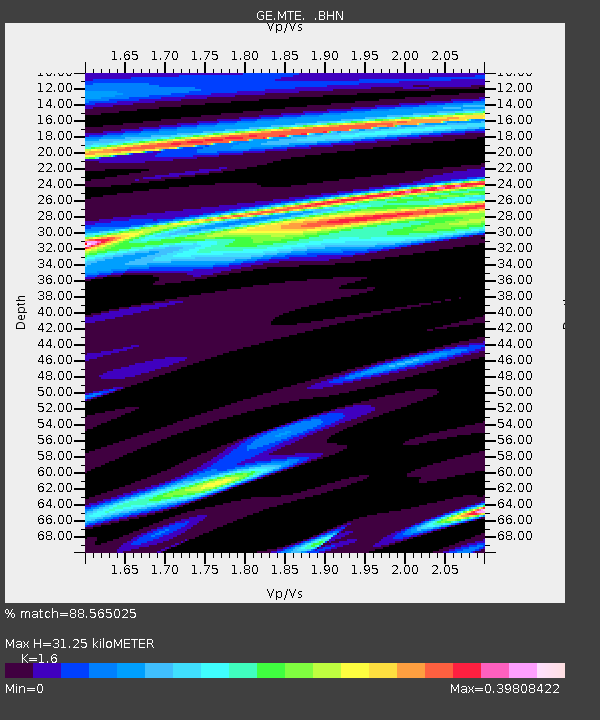
| Estimated Moho Depth: |
31.25 km |
| Estimated Crust Vp/Vs: |
1.60 |
| Assumed Crust Vp: |
6.276 km/s |
| Estimated Crust Vs: |
3.922 km/s |
| Estimated Crust Poisson's Ratio: |
0.18 |
|
| Radial Match: |
88.565025 % |
| Radial Bump: |
346 |
| Transverse Match: |
71.35951 % |
| Transverse Bump: |
400 |
| SOD ConfigId: |
3744 |
| Insert Time: |
2010-03-09 04:57:55.327 +0000 |
| GWidth: |
2.5 |
| Max Bumps: |
400 |
| Tol: |
0.001 |
|

Signal To Noise
| Channel | StoN | STA | LTA |
| GE:MTE: :BHN:20001002T02:35:01.507021Z | 1.7398462 | 4.874836E-7 | 2.8018775E-7 |
| GE:MTE: :BHE:20001002T02:35:01.507021Z | 3.5877774 | 5.5825694E-7 | 1.5559966E-7 |
| GE:MTE: :BHZ:20001002T02:35:01.507021Z | 2.7322903 | 1.4416028E-6 | 5.27617E-7 |
| Arrivals |
| Ps | 3.1 SECOND |
| PpPs | 12 SECOND |
| PsPs/PpSs | 15 SECOND |


