You are here: Home > Network List > GE - GEOFON Stations List
> Station MTE GEOFON Station Manteigas, Portugal > Earthquake Result Viewer
MTE GEOFON Station Manteigas, Portugal - Earthquake Result Viewer
| Earthquake location: |
Turkey |
| Earthquake latitude/longitude: |
40.7/33.0 |
| Earthquake time(UTC): |
2000/06/06 (158) 02:41:49 GMT |
| Earthquake Depth: |
10 km |
| Earthquake Magnitude: |
5.5 MB, 6.1 MS, 6.1 MW, 6.0 MW |
| Earthquake Catalog/Contributor: |
WHDF/NEIC |
|
| Network: |
GE GEOFON |
| Station: |
MTE GEOFON Station Manteigas, Portugal |
| Lat/Lon: |
40.40 N/7.54 W |
| Elevation: |
815 m |
|
| Distance: |
30.6 deg |
| Az: |
282.928 deg |
| Baz: |
76.031 deg |
| Ray Param: |
0.07928589 |
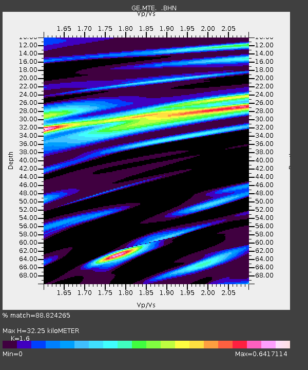
| Estimated Moho Depth: |
32.25 km |
| Estimated Crust Vp/Vs: |
1.60 |
| Assumed Crust Vp: |
6.276 km/s |
| Estimated Crust Vs: |
3.922 km/s |
| Estimated Crust Poisson's Ratio: |
0.18 |
|
| Radial Match: |
88.824265 % |
| Radial Bump: |
313 |
| Transverse Match: |
61.851803 % |
| Transverse Bump: |
400 |
| SOD ConfigId: |
3744 |
| Insert Time: |
2010-03-09 04:58:03.990 +0000 |
| GWidth: |
2.5 |
| Max Bumps: |
400 |
| Tol: |
0.001 |
|

Signal To Noise
| Channel | StoN | STA | LTA |
| GE:MTE: :BHN:20000606T02:47:33.257001Z | 1.252623 | 1.1837513E-7 | 9.45018E-8 |
| GE:MTE: :BHE:20000606T02:47:33.257001Z | 4.9411664 | 4.6053836E-7 | 9.320438E-8 |
| GE:MTE: :BHZ:20000606T02:47:33.257001Z | 6.1068177 | 6.7629475E-7 | 1.1074422E-7 |
| Arrivals |
| Ps | 3.4 SECOND |
| PpPs | 12 SECOND |
| PsPs/PpSs | 16 SECOND |


