You are here: Home > Network List > US - United States National Seismic Network Stations List
> Station MSO Missoula, Montana, USA > Earthquake Result Viewer
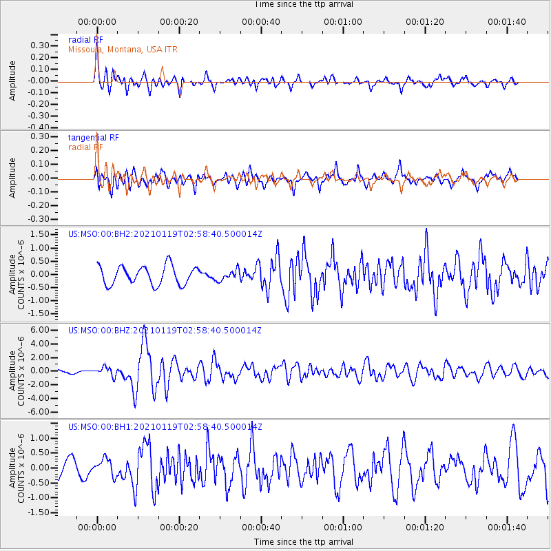
MSO Missoula, Montana, USA - Earthquake Result Viewer
*The percent match for this event was below the threshold and hence no stack was calculated.
| Earthquake location: |
San Juan Province, Argentina |
| Earthquake latitude/longitude: |
-31.8/-68.8 |
| Earthquake time(UTC): |
2021/01/19 (019) 02:46:22 GMT |
| Earthquake Depth: |
20 km |
| Earthquake Magnitude: |
6.4 mww |
| Earthquake Catalog/Contributor: |
NEIC PDE/us |
|
| Network: |
US United States National Seismic Network |
| Station: |
MSO Missoula, Montana, USA |
| Lat/Lon: |
46.83 N/113.94 W |
| Elevation: |
1264 m |
|
| Distance: |
88.2 deg |
| Az: |
330.887 deg |
| Baz: |
142.898 deg |
| Ray Param: |
$rayparam |
*The percent match for this event was below the threshold and hence was not used in the summary stack. |
|
| Radial Match: |
76.53502 % |
| Radial Bump: |
400 |
| Transverse Match: |
71.895294 % |
| Transverse Bump: |
400 |
| SOD ConfigId: |
23341671 |
| Insert Time: |
2021-02-02 04:11:04.390 +0000 |
| GWidth: |
2.5 |
| Max Bumps: |
400 |
| Tol: |
0.001 |
|
Signal To Noise
| Channel | StoN | STA | LTA |
| US:MSO:00:BHZ:20210119T02:58:40.500014Z | 2.2167299 | 6.5531435E-7 | 2.956221E-7 |
| US:MSO:00:BH1:20210119T02:58:40.500014Z | 0.9727922 | 2.8542382E-7 | 2.9340677E-7 |
| US:MSO:00:BH2:20210119T02:58:40.500014Z | 0.5649127 | 1.9739775E-7 | 3.4943054E-7 |
| Arrivals |
| Ps | |
| PpPs | |
| PsPs/PpSs | |


