You are here: Home > Network List > GS - US Geological Survey Networks Stations List
> Station MT03 Stemple Pass Rd, Helena Natl Forest, Montana, USA > Earthquake Result Viewer
MT03 Stemple Pass Rd, Helena Natl Forest, Montana, USA - Earthquake Result Viewer
| Earthquake location: |
Off East Coast Of Honshu, Japan |
| Earthquake latitude/longitude: |
37.5/144.0 |
| Earthquake time(UTC): |
2017/10/06 (279) 07:59:33 GMT |
| Earthquake Depth: |
10 km |
| Earthquake Magnitude: |
6.0 Mww |
| Earthquake Catalog/Contributor: |
NEIC PDE/us |
|
| Network: |
GS US Geological Survey Networks |
| Station: |
MT03 Stemple Pass Rd, Helena Natl Forest, Montana, USA |
| Lat/Lon: |
46.91 N/112.50 W |
| Elevation: |
2025 m |
|
| Distance: |
71.7 deg |
| Az: |
44.574 deg |
| Baz: |
305.475 deg |
| Ray Param: |
0.05412959 |
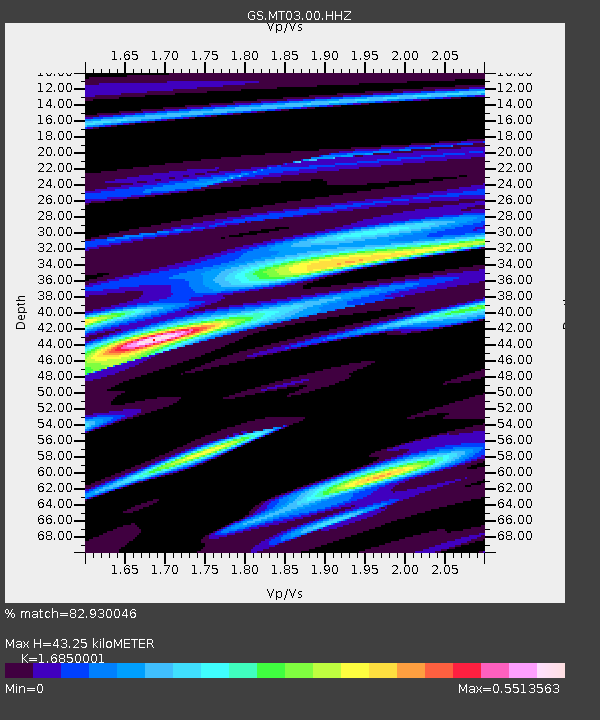
| Estimated Moho Depth: |
43.25 km |
| Estimated Crust Vp/Vs: |
1.69 |
| Assumed Crust Vp: |
6.353 km/s |
| Estimated Crust Vs: |
3.77 km/s |
| Estimated Crust Poisson's Ratio: |
0.23 |
|
| Radial Match: |
82.930046 % |
| Radial Bump: |
400 |
| Transverse Match: |
60.911747 % |
| Transverse Bump: |
400 |
| SOD ConfigId: |
2364251 |
| Insert Time: |
2017-10-20 08:02:55.144 +0000 |
| GWidth: |
2.5 |
| Max Bumps: |
400 |
| Tol: |
0.001 |
|

Signal To Noise
| Channel | StoN | STA | LTA |
| GS:MT03:00:HHZ:20171006T08:10:24.063979Z | 10.581148 | 1.165662E-6 | 1.1016403E-7 |
| GS:MT03:00:HH1:20171006T08:10:24.063979Z | 1.3232595 | 1.7830683E-7 | 1.347482E-7 |
| GS:MT03:00:HH2:20171006T08:10:24.063979Z | 2.50448 | 3.9569116E-7 | 1.5799336E-7 |
| Arrivals |
| Ps | 4.8 SECOND |
| PpPs | 18 SECOND |
| PsPs/PpSs | 22 SECOND |


