You are here: Home > Network List > UU - University of Utah Regional Network Stations List
> Station FOR1 Milford Southwest, UT, USA > Earthquake Result Viewer
FOR1 Milford Southwest, UT, USA - Earthquake Result Viewer
| Earthquake location: |
San Juan Province, Argentina |
| Earthquake latitude/longitude: |
-31.8/-68.8 |
| Earthquake time(UTC): |
2021/01/19 (019) 02:46:22 GMT |
| Earthquake Depth: |
20 km |
| Earthquake Magnitude: |
6.4 mww |
| Earthquake Catalog/Contributor: |
NEIC PDE/us |
|
| Network: |
UU University of Utah Regional Network |
| Station: |
FOR1 Milford Southwest, UT, USA |
| Lat/Lon: |
38.37 N/113.09 W |
| Elevation: |
1642 m |
|
| Distance: |
81.1 deg |
| Az: |
326.277 deg |
| Baz: |
143.04 deg |
| Ray Param: |
0.047823604 |
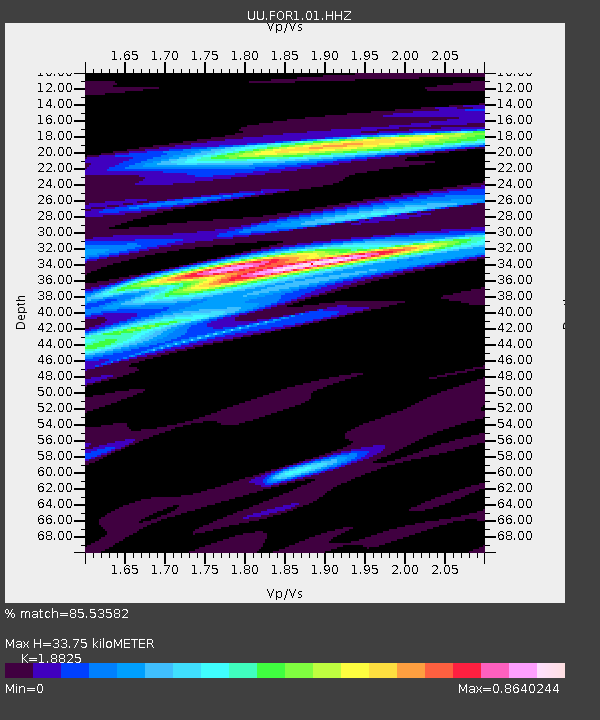
| Estimated Moho Depth: |
33.75 km |
| Estimated Crust Vp/Vs: |
1.88 |
| Assumed Crust Vp: |
6.276 km/s |
| Estimated Crust Vs: |
3.334 km/s |
| Estimated Crust Poisson's Ratio: |
0.30 |
|
| Radial Match: |
85.53582 % |
| Radial Bump: |
400 |
| Transverse Match: |
65.136566 % |
| Transverse Bump: |
400 |
| SOD ConfigId: |
23341671 |
| Insert Time: |
2021-02-02 04:11:38.121 +0000 |
| GWidth: |
2.5 |
| Max Bumps: |
400 |
| Tol: |
0.001 |
|

Signal To Noise
| Channel | StoN | STA | LTA |
| UU:FOR1:01:HHZ:20210119T02:58:04.659987Z | 5.480322 | 2.6321858E-8 | 4.8029767E-9 |
| UU:FOR1:01:HHN:20210119T02:58:04.659987Z | 1.1159953 | 8.421095E-9 | 7.5458155E-9 |
| UU:FOR1:01:HHE:20210119T02:58:04.659987Z | 1.5070648 | 7.3873387E-9 | 4.9018056E-9 |
| Arrivals |
| Ps | 4.9 SECOND |
| PpPs | 15 SECOND |
| PsPs/PpSs | 20 SECOND |


