You are here: Home > Network List > GE - GEOFON Stations List
> Station MTE GEOFON Station Manteigas, Portugal > Earthquake Result Viewer
MTE GEOFON Station Manteigas, Portugal - Earthquake Result Viewer
| Earthquake location: |
Hindu Kush Region, Afghanistan |
| Earthquake latitude/longitude: |
36.4/70.9 |
| Earthquake time(UTC): |
2001/02/25 (056) 02:21:59 GMT |
| Earthquake Depth: |
202 km |
| Earthquake Magnitude: |
5.8 MB, 6.3 MW, 6.1 MW |
| Earthquake Catalog/Contributor: |
WHDF/NEIC |
|
| Network: |
GE GEOFON |
| Station: |
MTE GEOFON Station Manteigas, Portugal |
| Lat/Lon: |
40.40 N/7.54 W |
| Elevation: |
815 m |
|
| Distance: |
59.7 deg |
| Az: |
299.894 deg |
| Baz: |
66.291 deg |
| Ray Param: |
0.061392546 |
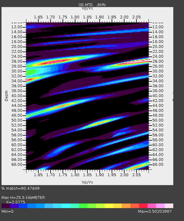
| Estimated Moho Depth: |
25.5 km |
| Estimated Crust Vp/Vs: |
2.08 |
| Assumed Crust Vp: |
6.276 km/s |
| Estimated Crust Vs: |
3.021 km/s |
| Estimated Crust Poisson's Ratio: |
0.35 |
|
| Radial Match: |
90.47649 % |
| Radial Bump: |
400 |
| Transverse Match: |
66.09035 % |
| Transverse Bump: |
400 |
| SOD ConfigId: |
3744 |
| Insert Time: |
2010-03-09 04:58:21.124 +0000 |
| GWidth: |
2.5 |
| Max Bumps: |
400 |
| Tol: |
0.001 |
|

Signal To Noise
| Channel | StoN | STA | LTA |
| GE:MTE: :BHN:20010225T02:31:11.607029Z | 0.85594094 | 1.7326622E-7 | 2.0242777E-7 |
| GE:MTE: :BHE:20010225T02:31:11.607029Z | 2.7612004 | 2.7690638E-7 | 1.0028479E-7 |
| GE:MTE: :BHZ:20010225T02:31:11.607029Z | 4.487126 | 9.821983E-7 | 2.1889254E-7 |
| Arrivals |
| Ps | 4.5 SECOND |
| PpPs | 12 SECOND |
| PsPs/PpSs | 17 SECOND |


