You are here: Home > Network List > UU - University of Utah Regional Network Stations List
> Station HMU Henry Mountain, UT, USA > Earthquake Result Viewer
HMU Henry Mountain, UT, USA - Earthquake Result Viewer
| Earthquake location: |
San Juan Province, Argentina |
| Earthquake latitude/longitude: |
-31.8/-68.8 |
| Earthquake time(UTC): |
2021/01/19 (019) 02:46:22 GMT |
| Earthquake Depth: |
20 km |
| Earthquake Magnitude: |
6.4 mww |
| Earthquake Catalog/Contributor: |
NEIC PDE/us |
|
| Network: |
UU University of Utah Regional Network |
| Station: |
HMU Henry Mountain, UT, USA |
| Lat/Lon: |
37.94 N/110.74 W |
| Elevation: |
2430 m |
|
| Distance: |
79.6 deg |
| Az: |
327.539 deg |
| Baz: |
144.698 deg |
| Ray Param: |
0.04880566 |
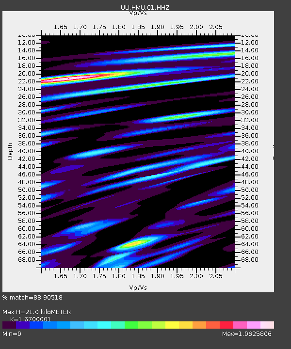
| Estimated Moho Depth: |
21.0 km |
| Estimated Crust Vp/Vs: |
1.67 |
| Assumed Crust Vp: |
6.247 km/s |
| Estimated Crust Vs: |
3.74 km/s |
| Estimated Crust Poisson's Ratio: |
0.22 |
|
| Radial Match: |
88.90518 % |
| Radial Bump: |
400 |
| Transverse Match: |
81.020256 % |
| Transverse Bump: |
400 |
| SOD ConfigId: |
23341671 |
| Insert Time: |
2021-02-02 04:11:43.994 +0000 |
| GWidth: |
2.5 |
| Max Bumps: |
400 |
| Tol: |
0.001 |
|

Signal To Noise
| Channel | StoN | STA | LTA |
| UU:HMU:01:HHZ:20210119T02:57:56.938002Z | 9.397703 | 4.2851333E-8 | 4.5597663E-9 |
| UU:HMU:01:HHN:20210119T02:57:56.938002Z | 2.4694982 | 1.37442795E-8 | 5.5656164E-9 |
| UU:HMU:01:HHE:20210119T02:57:56.938002Z | 2.7500591 | 1.5242314E-8 | 5.54254E-9 |
| Arrivals |
| Ps | 2.3 SECOND |
| PpPs | 8.7 SECOND |
| PsPs/PpSs | 11 SECOND |


