You are here: Home > Network List > YX16 - Raton Basin UNM Broadband Network Stations List
> Station UNM2 SE Corner of NM Stations > Earthquake Result Viewer
UNM2 SE Corner of NM Stations - Earthquake Result Viewer
| Earthquake location: |
San Juan Province, Argentina |
| Earthquake latitude/longitude: |
-31.8/-68.8 |
| Earthquake time(UTC): |
2021/01/19 (019) 02:46:22 GMT |
| Earthquake Depth: |
20 km |
| Earthquake Magnitude: |
6.4 mww |
| Earthquake Catalog/Contributor: |
NEIC PDE/us |
|
| Network: |
YX Raton Basin UNM Broadband Network |
| Station: |
UNM2 SE Corner of NM Stations |
| Lat/Lon: |
36.80 N/104.86 W |
| Elevation: |
2166 m |
|
| Distance: |
76.1 deg |
| Az: |
330.913 deg |
| Baz: |
148.961 deg |
| Ray Param: |
0.051183272 |
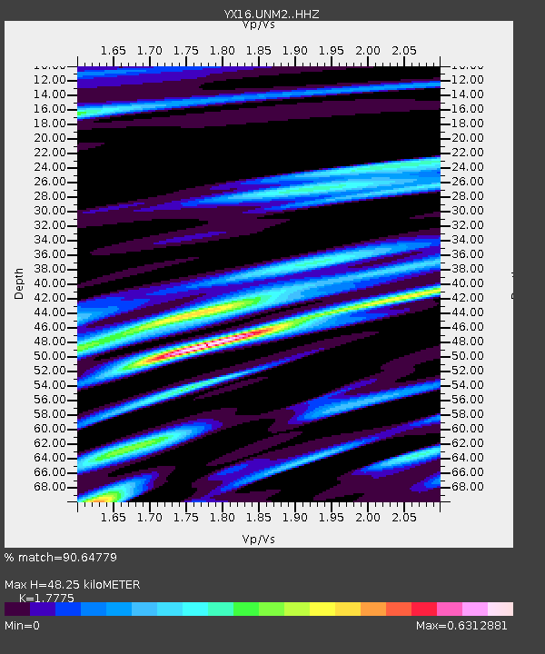
| Estimated Moho Depth: |
48.25 km |
| Estimated Crust Vp/Vs: |
1.78 |
| Assumed Crust Vp: |
6.316 km/s |
| Estimated Crust Vs: |
3.553 km/s |
| Estimated Crust Poisson's Ratio: |
0.27 |
|
| Radial Match: |
90.64779 % |
| Radial Bump: |
399 |
| Transverse Match: |
85.16063 % |
| Transverse Bump: |
330 |
| SOD ConfigId: |
23341671 |
| Insert Time: |
2021-02-02 04:14:23.267 +0000 |
| GWidth: |
2.5 |
| Max Bumps: |
400 |
| Tol: |
0.001 |
|

Signal To Noise
| Channel | StoN | STA | LTA |
| YX:UNM2: :HHZ:20210119T02:57:37.479994Z | 9.246104 | 1.4889104E-6 | 1.610311E-7 |
| YX:UNM2: :HHN:20210119T02:57:37.479994Z | 1.6752803 | 4.4324042E-7 | 2.6457687E-7 |
| YX:UNM2: :HHE:20210119T02:57:37.479994Z | 1.2654396 | 3.525094E-7 | 2.7856674E-7 |
| Arrivals |
| Ps | 6.1 SECOND |
| PpPs | 21 SECOND |
| PsPs/PpSs | 27 SECOND |


