You are here: Home > Network List > GE - GEOFON Stations List
> Station MTE GEOFON Station Manteigas, Portugal > Earthquake Result Viewer
MTE GEOFON Station Manteigas, Portugal - Earthquake Result Viewer
| Earthquake location: |
Central Mexico |
| Earthquake latitude/longitude: |
18.4/-97.4 |
| Earthquake time(UTC): |
1999/06/15 (166) 20:42:05 GMT |
| Earthquake Depth: |
70 km |
| Earthquake Magnitude: |
6.4 MB, 6.5 MS, 7.0 MW, 6.7 ME |
| Earthquake Catalog/Contributor: |
WHDF/NEIC |
|
| Network: |
GE GEOFON |
| Station: |
MTE GEOFON Station Manteigas, Portugal |
| Lat/Lon: |
40.40 N/7.54 W |
| Elevation: |
815 m |
|
| Distance: |
78.2 deg |
| Az: |
51.265 deg |
| Baz: |
284.086 deg |
| Ray Param: |
0.04962956 |
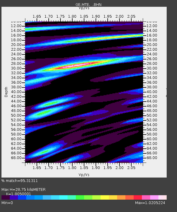
| Estimated Moho Depth: |
28.75 km |
| Estimated Crust Vp/Vs: |
1.81 |
| Assumed Crust Vp: |
6.276 km/s |
| Estimated Crust Vs: |
3.477 km/s |
| Estimated Crust Poisson's Ratio: |
0.28 |
|
| Radial Match: |
95.31311 % |
| Radial Bump: |
400 |
| Transverse Match: |
93.749725 % |
| Transverse Bump: |
400 |
| SOD ConfigId: |
4480 |
| Insert Time: |
2010-03-09 04:58:43.906 +0000 |
| GWidth: |
2.5 |
| Max Bumps: |
400 |
| Tol: |
0.001 |
|

Signal To Noise
| Channel | StoN | STA | LTA |
| GE:MTE: :BHN:19990615T20:53:27.041023Z | 27.969933 | 2.2030047E-6 | 7.876332E-8 |
| GE:MTE: :BHE:19990615T20:53:27.041023Z | 2.2440372 | 1.7742067E-7 | 7.906316E-8 |
| GE:MTE: :BHZ:19990615T20:53:27.041023Z | 9.385324 | 7.7961954E-7 | 8.306795E-8 |
| Arrivals |
| Ps | 3.8 SECOND |
| PpPs | 12 SECOND |
| PsPs/PpSs | 16 SECOND |


