You are here: Home > Network List > GE - GEOFON Stations List
> Station MTE GEOFON Station Manteigas, Portugal > Earthquake Result Viewer
MTE GEOFON Station Manteigas, Portugal - Earthquake Result Viewer
| Earthquake location: |
Leeward Islands |
| Earthquake latitude/longitude: |
15.7/-61.7 |
| Earthquake time(UTC): |
2004/11/21 (326) 11:41:07 GMT |
| Earthquake Depth: |
14 km |
| Earthquake Magnitude: |
6.3 MB, 6.1 MS, 6.3 MW, 6.3 MW |
| Earthquake Catalog/Contributor: |
WHDF/NEIC |
|
| Network: |
GE GEOFON |
| Station: |
MTE GEOFON Station Manteigas, Portugal |
| Lat/Lon: |
40.40 N/7.54 W |
| Elevation: |
815 m |
|
| Distance: |
52.8 deg |
| Az: |
50.975 deg |
| Baz: |
258.491 deg |
| Ray Param: |
0.06649334 |
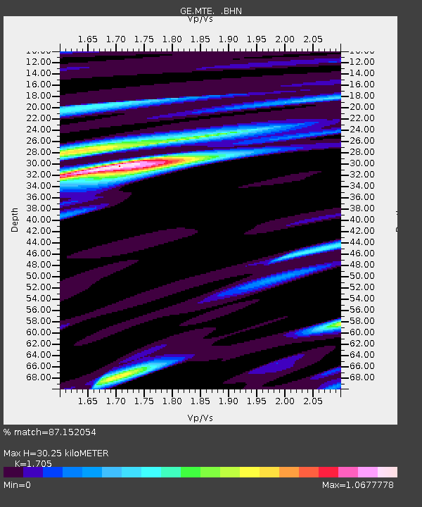
| Estimated Moho Depth: |
30.25 km |
| Estimated Crust Vp/Vs: |
1.71 |
| Assumed Crust Vp: |
6.276 km/s |
| Estimated Crust Vs: |
3.681 km/s |
| Estimated Crust Poisson's Ratio: |
0.24 |
|
| Radial Match: |
87.152054 % |
| Radial Bump: |
400 |
| Transverse Match: |
70.46656 % |
| Transverse Bump: |
400 |
| SOD ConfigId: |
2459 |
| Insert Time: |
2010-03-09 04:58:53.090 +0000 |
| GWidth: |
2.5 |
| Max Bumps: |
400 |
| Tol: |
0.001 |
|

Signal To Noise
| Channel | StoN | STA | LTA |
| GE:MTE: :BHN:20041121T11:49:51.731008Z | 0.7914917 | 8.710286E-8 | 1.10048994E-7 |
| GE:MTE: :BHE:20041121T11:49:51.731008Z | 1.1540751 | 1.8432243E-7 | 1.597144E-7 |
| GE:MTE: :BHZ:20041121T11:49:51.731008Z | 2.0948277 | 3.3318966E-7 | 1.590535E-7 |
| Arrivals |
| Ps | 3.6 SECOND |
| PpPs | 12 SECOND |
| PsPs/PpSs | 16 SECOND |


