You are here: Home > Network List > IU - Global Seismograph Network (GSN - IRIS/USGS) Stations List
> Station MAKZ Makanchi, Kazakhstan > Earthquake Result Viewer
MAKZ Makanchi, Kazakhstan - Earthquake Result Viewer
*The percent match for this event was below the threshold and hence no stack was calculated.
| Earthquake location: |
Sea Of Okhotsk |
| Earthquake latitude/longitude: |
49.7/147.7 |
| Earthquake time(UTC): |
2021/01/20 (020) 16:00:40 GMT |
| Earthquake Depth: |
575 km |
| Earthquake Magnitude: |
5.5 Mww |
| Earthquake Catalog/Contributor: |
NEIC PDE/us |
|
| Network: |
IU Global Seismograph Network (GSN - IRIS/USGS) |
| Station: |
MAKZ Makanchi, Kazakhstan |
| Lat/Lon: |
46.81 N/81.98 E |
| Elevation: |
600 m |
|
| Distance: |
42.6 deg |
| Az: |
292.324 deg |
| Baz: |
60.93 deg |
| Ray Param: |
$rayparam |
*The percent match for this event was below the threshold and hence was not used in the summary stack. |
|
| Radial Match: |
78.276764 % |
| Radial Bump: |
400 |
| Transverse Match: |
51.4978 % |
| Transverse Bump: |
400 |
| SOD ConfigId: |
23341671 |
| Insert Time: |
2021-02-03 17:11:43.445 +0000 |
| GWidth: |
2.5 |
| Max Bumps: |
400 |
| Tol: |
0.001 |
|
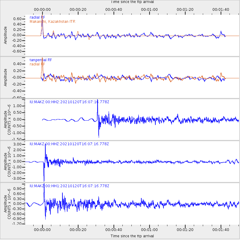
Signal To Noise
| Channel | StoN | STA | LTA |
| IU:MAKZ:00:HHZ:20210120T16:07:16.778Z | 10.242723 | 9.4848E-7 | 9.2600374E-8 |
| IU:MAKZ:00:HH1:20210120T16:07:16.778Z | 4.498617 | 3.4828986E-7 | 7.742154E-8 |
| IU:MAKZ:00:HH2:20210120T16:07:16.778Z | 6.7542048 | 4.0644096E-7 | 6.017599E-8 |
| Arrivals |
| Ps | |
| PpPs | |
| PsPs/PpSs | |


