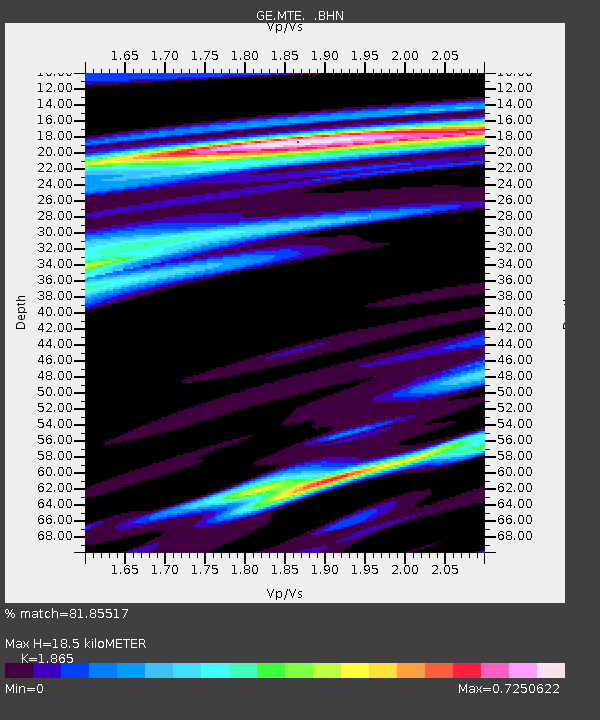
MTE GEOFON Station Manteigas, Portugal - Earthquake Result Viewer

Earthquake location: Off East Coast Of Honshu, Japan
Earthquake latitude/longitude: 38.1/144.9
Earthquake time(UTC): 2005/11/14 (318) 21:38:51 GMT
Earthquake Depth: 11 km
Earthquake Magnitude: 6.7 MB, 6.8 MS, 7.0 MW, 6.9 MW
Earthquake Catalog/Contributor: WHDF/NEIC
Network: GE GEOFON
Station: MTE GEOFON Station Manteigas, Portugal
Lat/Lon: 40.40 N/7.54 W
Elevation: 815 m
Distance: 97.9 deg
Az: 339.101 deg
Baz: 21.622 deg
Ray Param: 0.040073995
Estimated Moho Depth: 18.5 km
Estimated Crust Vp/Vs: 1.87
Assumed Crust Vp: 6.276 km/s
Estimated Crust Vs: 3.365 km/s
Estimated Crust Poisson's Ratio: 0.30
Radial Match: 81.85517 %
Radial Bump: 400
Transverse Match: 60.285545 %
Transverse Bump: 400
SOD ConfigId: 2448
Insert Time: 2010-03-09 04:59:08.757 +0000
GWidth: 2.5
Max Bumps: 400
Tol: 0.001

Signal To Noise

ChannelStoNSTALTA
GE:MTE: :BHN:20051114T21:51:55.263994Z1.12517753.6716042E-73.2631337E-7
GE:MTE: :BHE:20051114T21:51:55.263994Z0.736187762.0236735E-72.748855E-7
GE:MTE: :BHZ:20051114T21:51:55.263994Z2.62990711.0335013E-63.9298018E-7
Arrivals
Ps2.6 SECOND
PpPs8.3 SECOND
PsPs/PpSs11 SECOND