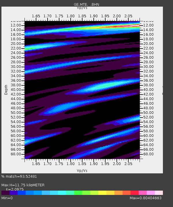
MTE GEOFON Station Manteigas, Portugal - Earthquake Result Viewer

Earthquake location: Near East Coast Of Honshu, Japan
Earthquake latitude/longitude: 38.3/142.0
Earthquake time(UTC): 2005/08/16 (228) 02:46:28 GMT
Earthquake Depth: 36 km
Earthquake Magnitude: 6.5 MB, 6.8 MS, 7.2 MW, 7.1 MW
Earthquake Catalog/Contributor: WHDF/NEIC
Network: GE GEOFON
Station: MTE GEOFON Station Manteigas, Portugal
Lat/Lon: 40.40 N/7.54 W
Elevation: 815 m
Distance: 96.9 deg
Az: 337.079 deg
Baz: 23.664 deg
Ray Param: 0.040358823
Estimated Moho Depth: 11.75 km
Estimated Crust Vp/Vs: 2.10
Assumed Crust Vp: 6.276 km/s
Estimated Crust Vs: 2.992 km/s
Estimated Crust Poisson's Ratio: 0.35
Radial Match: 93.52481 %
Radial Bump: 310
Transverse Match: 76.89786 %
Transverse Bump: 400
SOD ConfigId: 2475
Insert Time: 2010-03-09 04:59:16.134 +0000
GWidth: 2.5
Max Bumps: 400
Tol: 0.001

Signal To Noise

ChannelStoNSTALTA
GE:MTE: :BHN:20050816T02:59:24.452002Z6.36480055.460156E-78.578676E-8
GE:MTE: :BHE:20050816T02:59:24.452002Z2.14667492.827451E-71.3171305E-7
GE:MTE: :BHZ:20050816T02:59:24.452002Z11.02584652.0279526E-61.8392717E-7
Arrivals
Ps2.1 SECOND
PpPs5.7 SECOND
PsPs/PpSs7.8 SECOND