You are here: Home > Network List > UW - Pacific Northwest Regional Seismic Network Stations List
> Station YACT Amboy, WA, USA > Earthquake Result Viewer
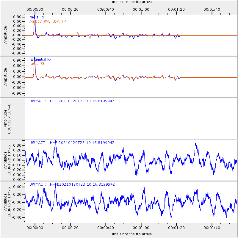
YACT Amboy, WA, USA - Earthquake Result Viewer
*The percent match for this event was below the threshold and hence no stack was calculated.
| Earthquake location: |
Near Coast Of Peru |
| Earthquake latitude/longitude: |
-15.0/-75.5 |
| Earthquake time(UTC): |
2021/01/20 (020) 22:59:12 GMT |
| Earthquake Depth: |
10 km |
| Earthquake Magnitude: |
5.5 Mww |
| Earthquake Catalog/Contributor: |
NEIC PDE/us |
|
| Network: |
UW Pacific Northwest Regional Seismic Network |
| Station: |
YACT Amboy, WA, USA |
| Lat/Lon: |
45.93 N/122.42 W |
| Elevation: |
211 m |
|
| Distance: |
74.0 deg |
| Az: |
327.977 deg |
| Baz: |
132.765 deg |
| Ray Param: |
$rayparam |
*The percent match for this event was below the threshold and hence was not used in the summary stack. |
|
| Radial Match: |
89.55771 % |
| Radial Bump: |
307 |
| Transverse Match: |
89.55772 % |
| Transverse Bump: |
307 |
| SOD ConfigId: |
23341671 |
| Insert Time: |
2021-02-04 00:15:34.504 +0000 |
| GWidth: |
2.5 |
| Max Bumps: |
400 |
| Tol: |
0.001 |
|
Signal To Noise
| Channel | StoN | STA | LTA |
| UW:YACT: :HHZ:20210120T23:10:16.819994Z | 0.80003715 | 1.1925707E-7 | 1.490644E-7 |
| UW:YACT: :HHN:20210120T23:10:16.819994Z | 0.92130023 | 1.759516E-7 | 1.9098184E-7 |
| $trig.getChannelId() | $trig.getValue() | $trig.getSTA() | $trig.getLTA() |
| Arrivals |
| Ps | |
| PpPs | |
| PsPs/PpSs | |


