You are here: Home > Network List > AK - Alaska Regional Network Stations List
> Station FYU Fort Yukon, Alaska, USA > Earthquake Result Viewer
FYU Fort Yukon, Alaska, USA - Earthquake Result Viewer
| Earthquake location: |
Philippine Islands Region |
| Earthquake latitude/longitude: |
5.0/127.5 |
| Earthquake time(UTC): |
2021/01/21 (021) 12:23:05 GMT |
| Earthquake Depth: |
96 km |
| Earthquake Magnitude: |
7.0 mww |
| Earthquake Catalog/Contributor: |
NEIC PDE/us |
|
| Network: |
AK Alaska Regional Network |
| Station: |
FYU Fort Yukon, Alaska, USA |
| Lat/Lon: |
66.57 N/145.23 W |
| Elevation: |
137 m |
|
| Distance: |
84.3 deg |
| Az: |
23.668 deg |
| Baz: |
269.475 deg |
| Ray Param: |
0.04535162 |
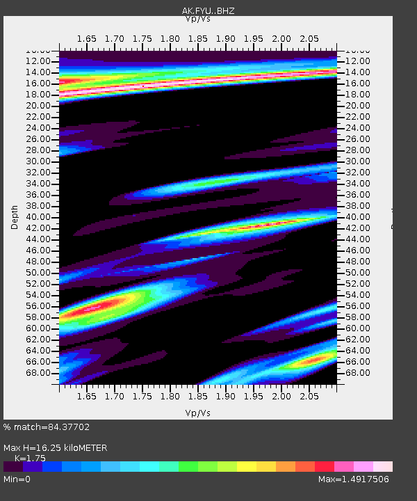
| Estimated Moho Depth: |
16.25 km |
| Estimated Crust Vp/Vs: |
1.75 |
| Assumed Crust Vp: |
6.522 km/s |
| Estimated Crust Vs: |
3.727 km/s |
| Estimated Crust Poisson's Ratio: |
0.26 |
|
| Radial Match: |
84.37702 % |
| Radial Bump: |
373 |
| Transverse Match: |
71.84165 % |
| Transverse Bump: |
400 |
| SOD ConfigId: |
23341671 |
| Insert Time: |
2021-02-04 13:25:09.319 +0000 |
| GWidth: |
2.5 |
| Max Bumps: |
400 |
| Tol: |
0.001 |
|

Signal To Noise
| Channel | StoN | STA | LTA |
| AK:FYU: :BHZ:20210121T12:34:56.107984Z | 13.896585 | 5.3003096E-6 | 3.814109E-7 |
| AK:FYU: :BHN:20210121T12:34:56.107984Z | 1.6898553 | 1.9427314E-6 | 1.1496436E-6 |
| AK:FYU: :BHE:20210121T12:34:56.107984Z | 2.2482786 | 2.980993E-6 | 1.3259001E-6 |
| Arrivals |
| Ps | 1.9 SECOND |
| PpPs | 6.7 SECOND |
| PsPs/PpSs | 8.6 SECOND |


