You are here: Home > Network List > AK - Alaska Regional Network Stations List
> Station GOAT Goat Mountain, AK, USA > Earthquake Result Viewer
GOAT Goat Mountain, AK, USA - Earthquake Result Viewer
| Earthquake location: |
Philippine Islands Region |
| Earthquake latitude/longitude: |
5.0/127.5 |
| Earthquake time(UTC): |
2021/01/21 (021) 12:23:05 GMT |
| Earthquake Depth: |
96 km |
| Earthquake Magnitude: |
7.0 mww |
| Earthquake Catalog/Contributor: |
NEIC PDE/us |
|
| Network: |
AK Alaska Regional Network |
| Station: |
GOAT Goat Mountain, AK, USA |
| Lat/Lon: |
60.58 N/144.73 W |
| Elevation: |
896 m |
|
| Distance: |
84.6 deg |
| Az: |
29.706 deg |
| Baz: |
270.509 deg |
| Ray Param: |
0.04519142 |
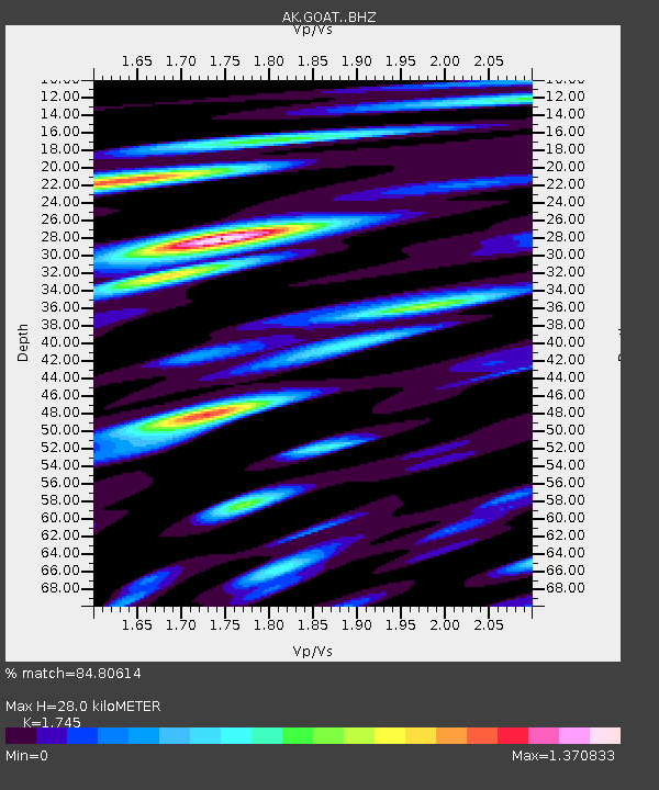
| Estimated Moho Depth: |
28.0 km |
| Estimated Crust Vp/Vs: |
1.75 |
| Assumed Crust Vp: |
6.566 km/s |
| Estimated Crust Vs: |
3.763 km/s |
| Estimated Crust Poisson's Ratio: |
0.26 |
|
| Radial Match: |
84.80614 % |
| Radial Bump: |
400 |
| Transverse Match: |
79.703094 % |
| Transverse Bump: |
400 |
| SOD ConfigId: |
23341671 |
| Insert Time: |
2021-02-04 13:25:18.076 +0000 |
| GWidth: |
2.5 |
| Max Bumps: |
400 |
| Tol: |
0.001 |
|

Signal To Noise
| Channel | StoN | STA | LTA |
| AK:GOAT: :BHZ:20210121T12:34:57.247999Z | 11.25 | 5.7384214E-6 | 5.100819E-7 |
| AK:GOAT: :BHN:20210121T12:34:57.247999Z | 1.3681246 | 1.5330843E-6 | 1.1205735E-6 |
| AK:GOAT: :BHE:20210121T12:34:57.247999Z | 4.898467 | 2.174559E-6 | 4.4392644E-7 |
| Arrivals |
| Ps | 3.3 SECOND |
| PpPs | 11 SECOND |
| PsPs/PpSs | 15 SECOND |


