You are here: Home > Network List > AK - Alaska Regional Network Stations List
> Station WAT7 Susitna Watana 7, AK, USA > Earthquake Result Viewer
WAT7 Susitna Watana 7, AK, USA - Earthquake Result Viewer
| Earthquake location: |
Philippine Islands Region |
| Earthquake latitude/longitude: |
5.0/127.5 |
| Earthquake time(UTC): |
2021/01/21 (021) 12:23:05 GMT |
| Earthquake Depth: |
96 km |
| Earthquake Magnitude: |
7.0 mww |
| Earthquake Catalog/Contributor: |
NEIC PDE/us |
|
| Network: |
AK Alaska Regional Network |
| Station: |
WAT7 Susitna Watana 7, AK, USA |
| Lat/Lon: |
62.83 N/148.85 W |
| Elevation: |
1232 m |
|
| Distance: |
82.7 deg |
| Az: |
27.384 deg |
| Baz: |
266.629 deg |
| Ray Param: |
0.046531722 |
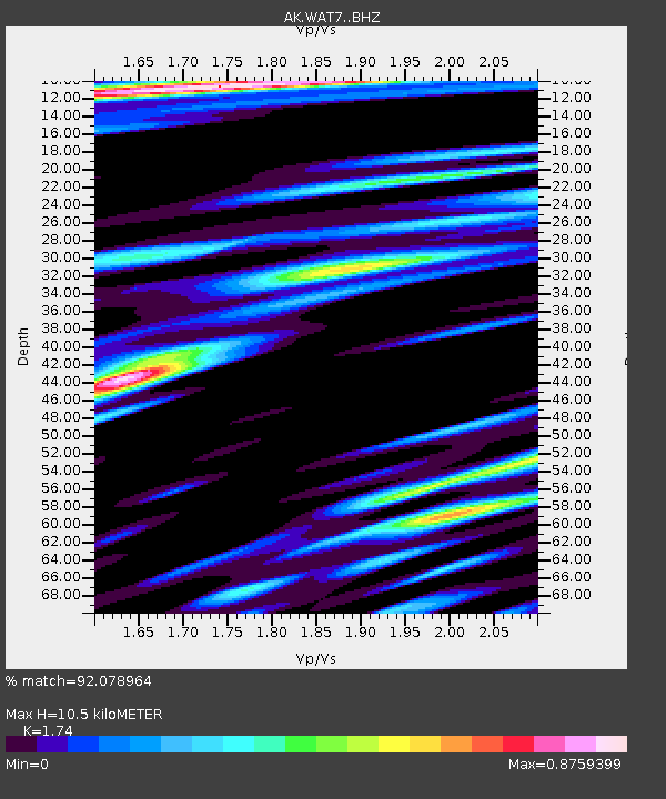
| Estimated Moho Depth: |
10.5 km |
| Estimated Crust Vp/Vs: |
1.74 |
| Assumed Crust Vp: |
6.566 km/s |
| Estimated Crust Vs: |
3.774 km/s |
| Estimated Crust Poisson's Ratio: |
0.25 |
|
| Radial Match: |
92.078964 % |
| Radial Bump: |
400 |
| Transverse Match: |
88.84381 % |
| Transverse Bump: |
400 |
| SOD ConfigId: |
23341671 |
| Insert Time: |
2021-02-04 13:27:06.259 +0000 |
| GWidth: |
2.5 |
| Max Bumps: |
400 |
| Tol: |
0.001 |
|

Signal To Noise
| Channel | StoN | STA | LTA |
| AK:WAT7: :BHZ:20210121T12:34:47.547987Z | 21.24762 | 5.3324047E-6 | 2.5096477E-7 |
| AK:WAT7: :BHN:20210121T12:34:47.547987Z | 1.6159171 | 5.6281885E-7 | 3.4829688E-7 |
| AK:WAT7: :BHE:20210121T12:34:47.547987Z | 10.3448925 | 2.4365345E-6 | 2.355302E-7 |
| Arrivals |
| Ps | 1.2 SECOND |
| PpPs | 4.3 SECOND |
| PsPs/PpSs | 5.5 SECOND |


