You are here: Home > Network List > AK - Alaska Regional Network Stations List
> Station PS06 TAPS Pump Station 6, AK, USA > Earthquake Result Viewer
PS06 TAPS Pump Station 6, AK, USA - Earthquake Result Viewer
| Earthquake location: |
Philippine Islands Region |
| Earthquake latitude/longitude: |
5.0/127.5 |
| Earthquake time(UTC): |
2021/01/21 (021) 12:23:05 GMT |
| Earthquake Depth: |
96 km |
| Earthquake Magnitude: |
7.0 mww |
| Earthquake Catalog/Contributor: |
NEIC PDE/us |
|
| Network: |
AK Alaska Regional Network |
| Station: |
PS06 TAPS Pump Station 6, AK, USA |
| Lat/Lon: |
65.85 N/149.74 W |
| Elevation: |
280 m |
|
| Distance: |
82.5 deg |
| Az: |
24.305 deg |
| Baz: |
265.43 deg |
| Ray Param: |
0.046654858 |
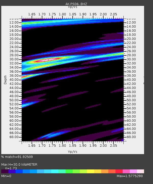
| Estimated Moho Depth: |
30.0 km |
| Estimated Crust Vp/Vs: |
1.73 |
| Assumed Crust Vp: |
6.566 km/s |
| Estimated Crust Vs: |
3.795 km/s |
| Estimated Crust Poisson's Ratio: |
0.25 |
|
| Radial Match: |
91.92589 % |
| Radial Bump: |
400 |
| Transverse Match: |
77.02104 % |
| Transverse Bump: |
400 |
| SOD ConfigId: |
23341671 |
| Insert Time: |
2021-02-04 13:27:14.919 +0000 |
| GWidth: |
2.5 |
| Max Bumps: |
400 |
| Tol: |
0.001 |
|

Signal To Noise
| Channel | StoN | STA | LTA |
| AK:PS06: :BHZ:20210121T12:34:46.648023Z | 21.687563 | 2.2783884E-6 | 1.05055065E-7 |
| AK:PS06: :BHN:20210121T12:34:46.648023Z | 5.356866 | 1.2060538E-6 | 2.2514168E-7 |
| AK:PS06: :BHE:20210121T12:34:46.648023Z | 4.2216477 | 1.2176569E-6 | 2.8843164E-7 |
| Arrivals |
| Ps | 3.4 SECOND |
| PpPs | 12 SECOND |
| PsPs/PpSs | 16 SECOND |


