You are here: Home > Network List > AK - Alaska Regional Network Stations List
> Station D25K Kavik River, AK, USA > Earthquake Result Viewer
D25K Kavik River, AK, USA - Earthquake Result Viewer
| Earthquake location: |
Philippine Islands Region |
| Earthquake latitude/longitude: |
5.0/127.5 |
| Earthquake time(UTC): |
2021/01/21 (021) 12:23:05 GMT |
| Earthquake Depth: |
96 km |
| Earthquake Magnitude: |
7.0 mww |
| Earthquake Catalog/Contributor: |
NEIC PDE/us |
|
| Network: |
AK Alaska Regional Network |
| Station: |
D25K Kavik River, AK, USA |
| Lat/Lon: |
69.32 N/146.38 W |
| Elevation: |
770 m |
|
| Distance: |
84.0 deg |
| Az: |
20.876 deg |
| Baz: |
268.132 deg |
| Ray Param: |
0.045612596 |
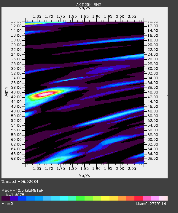
| Estimated Moho Depth: |
40.5 km |
| Estimated Crust Vp/Vs: |
1.69 |
| Assumed Crust Vp: |
6.378 km/s |
| Estimated Crust Vs: |
3.78 km/s |
| Estimated Crust Poisson's Ratio: |
0.23 |
|
| Radial Match: |
96.02684 % |
| Radial Bump: |
400 |
| Transverse Match: |
90.52291 % |
| Transverse Bump: |
400 |
| SOD ConfigId: |
23341671 |
| Insert Time: |
2021-02-04 13:27:37.265 +0000 |
| GWidth: |
2.5 |
| Max Bumps: |
400 |
| Tol: |
0.001 |
|

Signal To Noise
| Channel | StoN | STA | LTA |
| AK:D25K: :BHZ:20210121T12:34:54.240003Z | 21.313564 | 4.6203468E-6 | 2.1677964E-7 |
| AK:D25K: :BHN:20210121T12:34:54.240003Z | 2.8075495 | 5.9257985E-7 | 2.1106656E-7 |
| AK:D25K: :BHE:20210121T12:34:54.240003Z | 7.6314745 | 1.7564566E-6 | 2.3015953E-7 |
| Arrivals |
| Ps | 4.5 SECOND |
| PpPs | 17 SECOND |
| PsPs/PpSs | 21 SECOND |


