You are here: Home > Network List > GE - GEOFON Stations List
> Station KBS IRIS/GEOFON/AWI Station Ny Alesund, Spitsbergen > Earthquake Result Viewer
KBS IRIS/GEOFON/AWI Station Ny Alesund, Spitsbergen - Earthquake Result Viewer
| Earthquake location: |
Eastern Sea Of Japan |
| Earthquake latitude/longitude: |
43.2/138.9 |
| Earthquake time(UTC): |
1996/12/22 (357) 14:53:27 GMT |
| Earthquake Depth: |
227 km |
| Earthquake Magnitude: |
6.0 MB, 6.5 UNKNOWN, 6.5 MW |
| Earthquake Catalog/Contributor: |
WHDF/NEIC |
|
| Network: |
GE GEOFON |
| Station: |
KBS IRIS/GEOFON/AWI Station Ny Alesund, Spitsbergen |
| Lat/Lon: |
78.93 N/11.94 E |
| Elevation: |
77 m |
|
| Distance: |
54.2 deg |
| Az: |
349.029 deg |
| Baz: |
46.034 deg |
| Ray Param: |
0.06477078 |
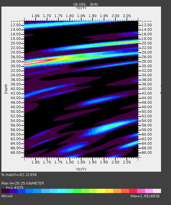
| Estimated Moho Depth: |
28.25 km |
| Estimated Crust Vp/Vs: |
1.63 |
| Assumed Crust Vp: |
6.287 km/s |
| Estimated Crust Vs: |
3.851 km/s |
| Estimated Crust Poisson's Ratio: |
0.20 |
|
| Radial Match: |
92.31959 % |
| Radial Bump: |
390 |
| Transverse Match: |
87.267815 % |
| Transverse Bump: |
400 |
| SOD ConfigId: |
6273 |
| Insert Time: |
2010-03-09 05:00:15.993 +0000 |
| GWidth: |
2.5 |
| Max Bumps: |
400 |
| Tol: |
0.001 |
|

Signal To Noise
| Channel | StoN | STA | LTA |
| GE:KBS: :BHN:19961222T15:01:59.265009Z | 28.624866 | 3.8360736E-6 | 1.3401191E-7 |
| GE:KBS: :BHE:19961222T15:01:59.265009Z | 41.96609 | 4.3400146E-6 | 1.0341718E-7 |
| GE:KBS: :BHZ:19961222T15:01:59.265009Z | 69.407585 | 1.366778E-5 | 1.9692055E-7 |
| Arrivals |
| Ps | 3.0 SECOND |
| PpPs | 11 SECOND |
| PsPs/PpSs | 14 SECOND |


