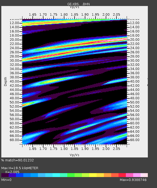
KBS IRIS/GEOFON/AWI Station Ny Alesund, Spitsbergen - Earthquake Result Viewer

Earthquake location: Bonin Islands, Japan Region
Earthquake latitude/longitude: 28.0/143.5
Earthquake time(UTC): 1996/11/06 (311) 20:00:58 GMT
Earthquake Depth: 9.0 km
Earthquake Magnitude: 6.4 MB, 6.5 MS, 6.6 UNKNOWN, 6.4 ME
Earthquake Catalog/Contributor: WHDF/NEIC
Network: GE GEOFON
Station: KBS IRIS/GEOFON/AWI Station Ny Alesund, Spitsbergen
Lat/Lon: 78.93 N/11.94 E
Elevation: 77 m
Distance: 69.8 deg
Az: 351.14 deg
Baz: 44.786 deg
Ray Param: 0.055383813
Estimated Moho Depth: 19.5 km
Estimated Crust Vp/Vs: 2.09
Assumed Crust Vp: 6.287 km/s
Estimated Crust Vs: 3.016 km/s
Estimated Crust Poisson's Ratio: 0.35
Radial Match: 90.01232 %
Radial Bump: 400
Transverse Match: 85.8646 %
Transverse Bump: 400
SOD ConfigId: 6273
Insert Time: 2010-03-09 05:00:17.229 +0000
GWidth: 2.5
Max Bumps: 400
Tol: 0.001

Signal To Noise

ChannelStoNSTALTA
GE:KBS: :BHN:19961106T20:11:38.385999Z1.09241393.3349795E-73.0528534E-7
GE:KBS: :BHE:19961106T20:11:38.385999Z1.30209343.8631913E-72.9669079E-7
GE:KBS: :BHZ:19961106T20:11:38.385999Z3.3381211.3641821E-64.086677E-7
Arrivals
Ps3.5 SECOND
PpPs9.3 SECOND
PsPs/PpSs13 SECOND