You are here: Home > Network List > AU - Australian Seismological Centre Stations List
> Station MEEK Meekatharra, Western Australia > Earthquake Result Viewer
MEEK Meekatharra, Western Australia - Earthquake Result Viewer
| Earthquake location: |
Philippine Islands Region |
| Earthquake latitude/longitude: |
5.0/127.5 |
| Earthquake time(UTC): |
2021/01/21 (021) 12:23:05 GMT |
| Earthquake Depth: |
96 km |
| Earthquake Magnitude: |
7.0 mww |
| Earthquake Catalog/Contributor: |
NEIC PDE/us |
|
| Network: |
AU Australian Seismological Centre |
| Station: |
MEEK Meekatharra, Western Australia |
| Lat/Lon: |
26.64 S/118.61 E |
| Elevation: |
530 m |
|
| Distance: |
32.6 deg |
| Az: |
194.89 deg |
| Baz: |
16.619 deg |
| Ray Param: |
0.07832236 |
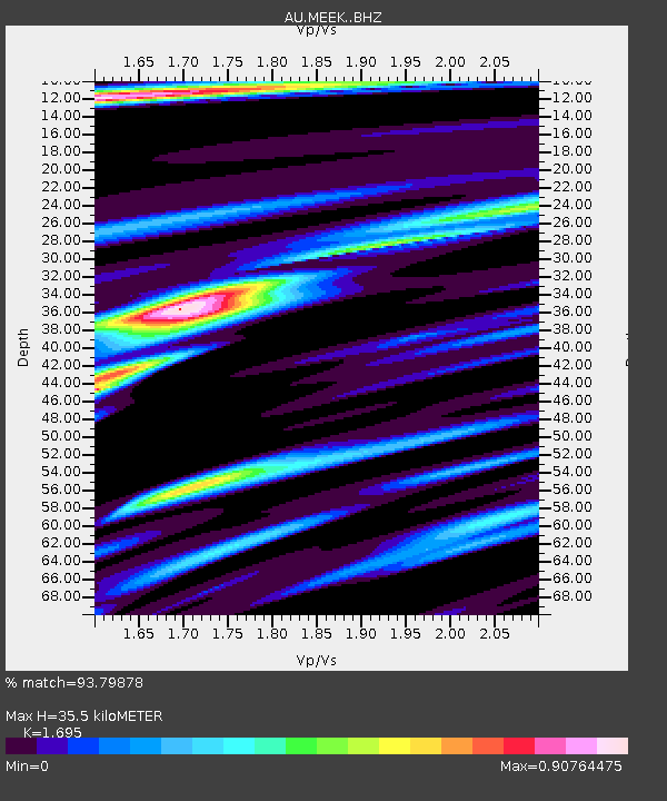
| Estimated Moho Depth: |
35.5 km |
| Estimated Crust Vp/Vs: |
1.70 |
| Assumed Crust Vp: |
6.459 km/s |
| Estimated Crust Vs: |
3.811 km/s |
| Estimated Crust Poisson's Ratio: |
0.23 |
|
| Radial Match: |
93.79878 % |
| Radial Bump: |
327 |
| Transverse Match: |
80.78713 % |
| Transverse Bump: |
400 |
| SOD ConfigId: |
23341671 |
| Insert Time: |
2021-02-04 13:28:41.903 +0000 |
| GWidth: |
2.5 |
| Max Bumps: |
400 |
| Tol: |
0.001 |
|

Signal To Noise
| Channel | StoN | STA | LTA |
| AU:MEEK: :BHZ:20210121T12:28:58.119001Z | 63.365868 | 1.4090868E-5 | 2.2237316E-7 |
| AU:MEEK: :BHN:20210121T12:28:58.119001Z | 67.20865 | 1.0118245E-5 | 1.5054974E-7 |
| AU:MEEK: :BHE:20210121T12:28:58.119001Z | 18.135355 | 3.7435152E-6 | 2.0642084E-7 |
| Arrivals |
| Ps | 4.2 SECOND |
| PpPs | 14 SECOND |
| PsPs/PpSs | 18 SECOND |


