You are here: Home > Network List > AV - Alaska Volcano Observatory Stations List
> Station ILS Iliamna South, Iliamna Volcano, Alaska > Earthquake Result Viewer
ILS Iliamna South, Iliamna Volcano, Alaska - Earthquake Result Viewer
| Earthquake location: |
Philippine Islands Region |
| Earthquake latitude/longitude: |
5.0/127.5 |
| Earthquake time(UTC): |
2021/01/21 (021) 12:23:05 GMT |
| Earthquake Depth: |
96 km |
| Earthquake Magnitude: |
7.0 mww |
| Earthquake Catalog/Contributor: |
NEIC PDE/us |
|
| Network: |
AV Alaska Volcano Observatory |
| Station: |
ILS Iliamna South, Iliamna Volcano, Alaska |
| Lat/Lon: |
59.96 N/153.07 W |
| Elevation: |
1125 m |
|
| Distance: |
80.4 deg |
| Az: |
30.109 deg |
| Baz: |
263.328 deg |
| Ray Param: |
0.048107147 |
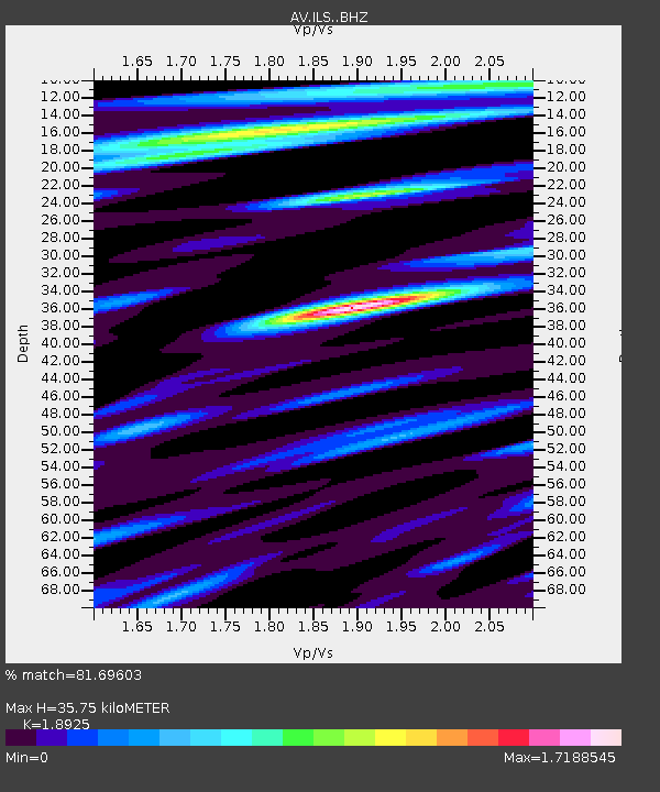
| Estimated Moho Depth: |
35.75 km |
| Estimated Crust Vp/Vs: |
1.89 |
| Assumed Crust Vp: |
5.989 km/s |
| Estimated Crust Vs: |
3.165 km/s |
| Estimated Crust Poisson's Ratio: |
0.31 |
|
| Radial Match: |
81.69603 % |
| Radial Bump: |
400 |
| Transverse Match: |
62.9143 % |
| Transverse Bump: |
400 |
| SOD ConfigId: |
23341671 |
| Insert Time: |
2021-02-04 13:29:44.693 +0000 |
| GWidth: |
2.5 |
| Max Bumps: |
400 |
| Tol: |
0.001 |
|
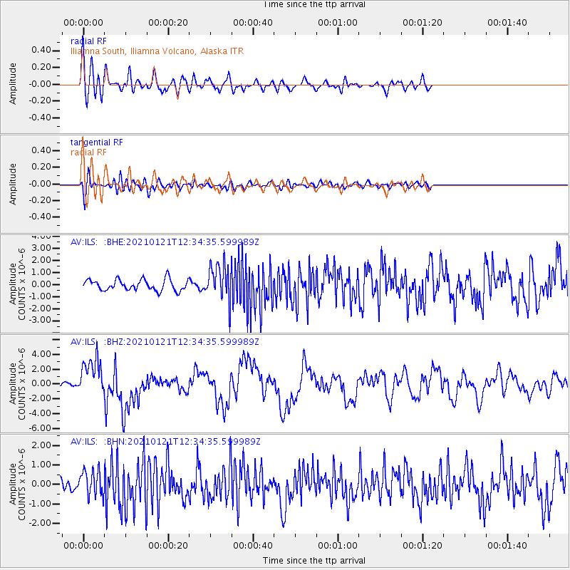
Signal To Noise
| Channel | StoN | STA | LTA |
| AV:ILS: :BHZ:20210121T12:34:35.599989Z | 10.367892 | 2.650151E-6 | 2.5561135E-7 |
| AV:ILS: :BHN:20210121T12:34:35.599989Z | 1.8206252 | 6.5552194E-7 | 3.600532E-7 |
| AV:ILS: :BHE:20210121T12:34:35.599989Z | 3.2390523 | 1.4722048E-6 | 4.5451714E-7 |
| Arrivals |
| Ps | 5.4 SECOND |
| PpPs | 17 SECOND |
| PsPs/PpSs | 22 SECOND |


