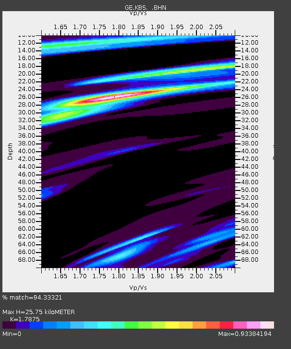
KBS IRIS/GEOFON/AWI Station Ny Alesund, Spitsbergen - Earthquake Result Viewer

Earthquake location: Rat Islands, Aleutian Islands
Earthquake latitude/longitude: 51.2/178.7
Earthquake time(UTC): 1996/03/22 (082) 03:24:20 GMT
Earthquake Depth: 20 km
Earthquake Magnitude: 5.7 MB, 6.6 MS, 6.8 UNKNOWN, 6.6 ML
Earthquake Catalog/Contributor: WHDF/NEIC
Network: GE GEOFON
Station: KBS IRIS/GEOFON/AWI Station Ny Alesund, Spitsbergen
Lat/Lon: 78.93 N/11.94 E
Elevation: 77 m
Distance: 49.9 deg
Az: 356.679 deg
Baz: 10.863 deg
Ray Param: 0.0683995
Estimated Moho Depth: 25.75 km
Estimated Crust Vp/Vs: 1.79
Assumed Crust Vp: 6.287 km/s
Estimated Crust Vs: 3.517 km/s
Estimated Crust Poisson's Ratio: 0.27
Radial Match: 94.33321 %
Radial Bump: 376
Transverse Match: 83.70979 %
Transverse Bump: 400
SOD ConfigId: 6273
Insert Time: 2010-03-09 05:00:34.894 +0000
GWidth: 2.5
Max Bumps: 400
Tol: 0.001

Signal To Noise

ChannelStoNSTALTA
GE:KBS: :BHN:19960322T03:32:40.989014Z6.4141979.1382856E-71.4246969E-7
GE:KBS: :BHE:19960322T03:32:40.989014Z2.06619793.4099074E-71.6503296E-7
GE:KBS: :BHZ:19960322T03:32:40.989014Z7.1772941.5529079E-62.1636399E-7
Arrivals
Ps3.4 SECOND
PpPs11 SECOND
PsPs/PpSs14 SECOND