You are here: Home > Network List > AV - Alaska Volcano Observatory Stations List
> Station KAHG Katmai Hook Glacier, Alaska > Earthquake Result Viewer
KAHG Katmai Hook Glacier, Alaska - Earthquake Result Viewer
| Earthquake location: |
Philippine Islands Region |
| Earthquake latitude/longitude: |
5.0/127.5 |
| Earthquake time(UTC): |
2021/01/21 (021) 12:23:05 GMT |
| Earthquake Depth: |
96 km |
| Earthquake Magnitude: |
7.0 mww |
| Earthquake Catalog/Contributor: |
NEIC PDE/us |
|
| Network: |
AV Alaska Volcano Observatory |
| Station: |
KAHG Katmai Hook Glacier, Alaska |
| Lat/Lon: |
58.49 N/154.55 W |
| Elevation: |
923 m |
|
| Distance: |
79.4 deg |
| Az: |
31.492 deg |
| Baz: |
262.302 deg |
| Ray Param: |
0.04874249 |
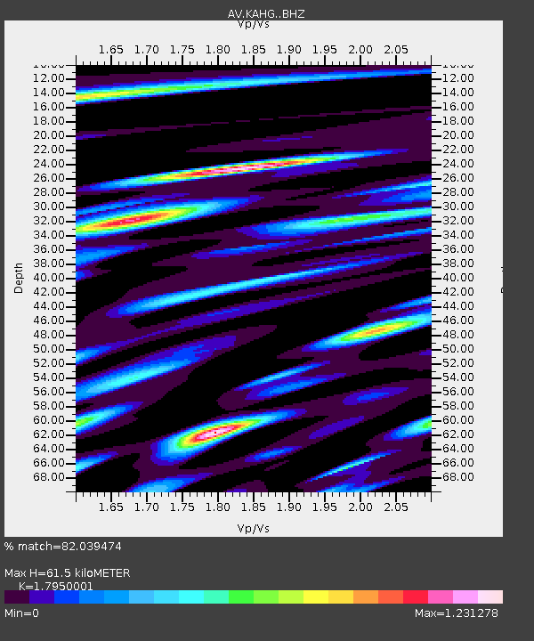
| Estimated Moho Depth: |
61.5 km |
| Estimated Crust Vp/Vs: |
1.80 |
| Assumed Crust Vp: |
6.438 km/s |
| Estimated Crust Vs: |
3.587 km/s |
| Estimated Crust Poisson's Ratio: |
0.27 |
|
| Radial Match: |
82.039474 % |
| Radial Bump: |
400 |
| Transverse Match: |
80.27107 % |
| Transverse Bump: |
400 |
| SOD ConfigId: |
23341671 |
| Insert Time: |
2021-02-04 13:29:51.511 +0000 |
| GWidth: |
2.5 |
| Max Bumps: |
400 |
| Tol: |
0.001 |
|

Signal To Noise
| Channel | StoN | STA | LTA |
| AV:KAHG: :BHZ:20210121T12:34:30.58003Z | 6.8725777 | 4.009911E-6 | 5.834654E-7 |
| AV:KAHG: :BHN:20210121T12:34:30.58003Z | 2.460815 | 1.2286763E-6 | 4.9929656E-7 |
| AV:KAHG: :BHE:20210121T12:34:30.58003Z | 3.3085268 | 1.5695624E-6 | 4.743992E-7 |
| Arrivals |
| Ps | 7.8 SECOND |
| PpPs | 26 SECOND |
| PsPs/PpSs | 34 SECOND |


