You are here: Home > Network List > GE - GEOFON Stations List
> Station KBS IRIS/GEOFON/AWI Station Ny Alesund, Spitsbergen > Earthquake Result Viewer
KBS IRIS/GEOFON/AWI Station Ny Alesund, Spitsbergen - Earthquake Result Viewer
| Earthquake location: |
Mariana Islands Region |
| Earthquake latitude/longitude: |
22.0/142.8 |
| Earthquake time(UTC): |
1996/07/06 (188) 21:36:28 GMT |
| Earthquake Depth: |
241 km |
| Earthquake Magnitude: |
5.8 MB, 6.3 UNKNOWN, 6.2 MW |
| Earthquake Catalog/Contributor: |
WHDF/NEIC |
|
| Network: |
GE GEOFON |
| Station: |
KBS IRIS/GEOFON/AWI Station Ny Alesund, Spitsbergen |
| Lat/Lon: |
78.93 N/11.94 E |
| Elevation: |
77 m |
|
| Distance: |
75.7 deg |
| Az: |
351.324 deg |
| Baz: |
46.409 deg |
| Ray Param: |
0.050861437 |
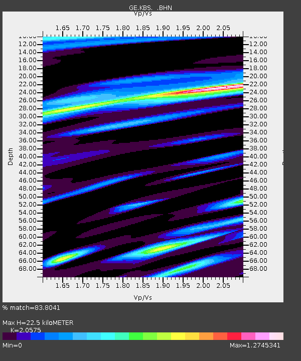
| Estimated Moho Depth: |
22.5 km |
| Estimated Crust Vp/Vs: |
2.06 |
| Assumed Crust Vp: |
6.287 km/s |
| Estimated Crust Vs: |
3.056 km/s |
| Estimated Crust Poisson's Ratio: |
0.35 |
|
| Radial Match: |
83.8041 % |
| Radial Bump: |
400 |
| Transverse Match: |
64.93176 % |
| Transverse Bump: |
400 |
| SOD ConfigId: |
6273 |
| Insert Time: |
2010-03-09 05:00:38.658 +0000 |
| GWidth: |
2.5 |
| Max Bumps: |
400 |
| Tol: |
0.001 |
|

Signal To Noise
| Channel | StoN | STA | LTA |
| GE:KBS: :BHN:19960706T21:47:16.390002Z | 2.558842 | 1.7891931E-7 | 6.992199E-8 |
| GE:KBS: :BHE:19960706T21:47:16.390002Z | 4.8205876 | 2.3612785E-7 | 4.898321E-8 |
| GE:KBS: :BHZ:19960706T21:47:16.390002Z | 12.596565 | 8.068086E-7 | 6.4049885E-8 |
| Arrivals |
| Ps | 3.9 SECOND |
| PpPs | 11 SECOND |
| PsPs/PpSs | 15 SECOND |


