You are here: Home > Network List > AV - Alaska Volcano Observatory Stations List
> Station MTBL Table Top, Makushin Volcano, Alaska > Earthquake Result Viewer
MTBL Table Top, Makushin Volcano, Alaska - Earthquake Result Viewer
| Earthquake location: |
Philippine Islands Region |
| Earthquake latitude/longitude: |
5.0/127.5 |
| Earthquake time(UTC): |
2021/01/21 (021) 12:23:05 GMT |
| Earthquake Depth: |
96 km |
| Earthquake Magnitude: |
7.0 mww |
| Earthquake Catalog/Contributor: |
NEIC PDE/us |
|
| Network: |
AV Alaska Volcano Observatory |
| Station: |
MTBL Table Top, Makushin Volcano, Alaska |
| Lat/Lon: |
53.97 N/166.68 W |
| Elevation: |
810 m |
|
| Distance: |
71.9 deg |
| Az: |
34.546 deg |
| Baz: |
252.976 deg |
| Ray Param: |
0.053813428 |
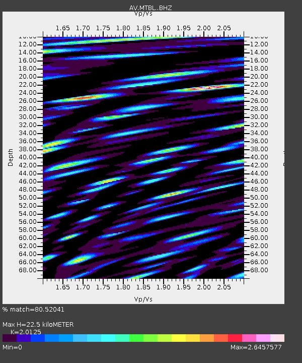
| Estimated Moho Depth: |
22.5 km |
| Estimated Crust Vp/Vs: |
2.01 |
| Assumed Crust Vp: |
3.943 km/s |
| Estimated Crust Vs: |
1.959 km/s |
| Estimated Crust Poisson's Ratio: |
0.34 |
|
| Radial Match: |
80.52041 % |
| Radial Bump: |
400 |
| Transverse Match: |
81.16641 % |
| Transverse Bump: |
400 |
| SOD ConfigId: |
23341671 |
| Insert Time: |
2021-02-04 13:30:22.187 +0000 |
| GWidth: |
2.5 |
| Max Bumps: |
400 |
| Tol: |
0.001 |
|

Signal To Noise
| Channel | StoN | STA | LTA |
| AV:MTBL: :BHZ:20210121T12:33:47.479994Z | 6.497927 | 1.2103558E-5 | 1.8626798E-6 |
| AV:MTBL: :BHN:20210121T12:33:47.479994Z | 3.6532376 | 9.800034E-6 | 2.6825612E-6 |
| AV:MTBL: :BHE:20210121T12:33:47.479994Z | 2.9803793 | 1.0944625E-5 | 3.6722254E-6 |
| Arrivals |
| Ps | 5.8 SECOND |
| PpPs | 17 SECOND |
| PsPs/PpSs | 23 SECOND |


