You are here: Home > Network List > AV - Alaska Volcano Observatory Stations List
> Station RDT Redoubt, Alaska > Earthquake Result Viewer
RDT Redoubt, Alaska - Earthquake Result Viewer
| Earthquake location: |
Philippine Islands Region |
| Earthquake latitude/longitude: |
5.0/127.5 |
| Earthquake time(UTC): |
2021/01/21 (021) 12:23:05 GMT |
| Earthquake Depth: |
96 km |
| Earthquake Magnitude: |
7.0 mww |
| Earthquake Catalog/Contributor: |
NEIC PDE/us |
|
| Network: |
AV Alaska Volcano Observatory |
| Station: |
RDT Redoubt, Alaska |
| Lat/Lon: |
60.57 N/152.41 W |
| Elevation: |
930 m |
|
| Distance: |
80.8 deg |
| Az: |
29.525 deg |
| Baz: |
263.806 deg |
| Ray Param: |
0.047838584 |
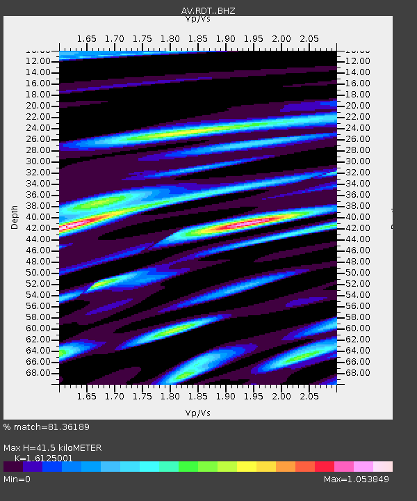
| Estimated Moho Depth: |
41.5 km |
| Estimated Crust Vp/Vs: |
1.61 |
| Assumed Crust Vp: |
6.566 km/s |
| Estimated Crust Vs: |
4.072 km/s |
| Estimated Crust Poisson's Ratio: |
0.19 |
|
| Radial Match: |
81.36189 % |
| Radial Bump: |
400 |
| Transverse Match: |
67.14524 % |
| Transverse Bump: |
400 |
| SOD ConfigId: |
23341671 |
| Insert Time: |
2021-02-04 13:30:39.193 +0000 |
| GWidth: |
2.5 |
| Max Bumps: |
400 |
| Tol: |
0.001 |
|

Signal To Noise
| Channel | StoN | STA | LTA |
| AV:RDT: :BHZ:20210121T12:34:37.719984Z | 9.332179 | 2.5566756E-6 | 2.739634E-7 |
| AV:RDT: :BHN:20210121T12:34:37.719984Z | 1.5133488 | 7.284046E-7 | 4.813197E-7 |
| AV:RDT: :BHE:20210121T12:34:37.719984Z | 1.3049899 | 5.353376E-7 | 4.1022358E-7 |
| Arrivals |
| Ps | 4.0 SECOND |
| PpPs | 16 SECOND |
| PsPs/PpSs | 20 SECOND |


