You are here: Home > Network List > GE - GEOFON Stations List
> Station KBS IRIS/GEOFON/AWI Station Ny Alesund, Spitsbergen > Earthquake Result Viewer
KBS IRIS/GEOFON/AWI Station Ny Alesund, Spitsbergen - Earthquake Result Viewer
| Earthquake location: |
Arabian Sea |
| Earthquake latitude/longitude: |
12.4/58.1 |
| Earthquake time(UTC): |
1996/10/01 (275) 15:50:23 GMT |
| Earthquake Depth: |
10 km |
| Earthquake Magnitude: |
5.8 MB, 5.9 MS, 6.4 UNKNOWN, 6.3 MW |
| Earthquake Catalog/Contributor: |
WHDF/NEIC |
|
| Network: |
GE GEOFON |
| Station: |
KBS IRIS/GEOFON/AWI Station Ny Alesund, Spitsbergen |
| Lat/Lon: |
78.93 N/11.94 E |
| Elevation: |
77 m |
|
| Distance: |
70.1 deg |
| Az: |
351.475 deg |
| Baz: |
131.497 deg |
| Ray Param: |
0.055224 |
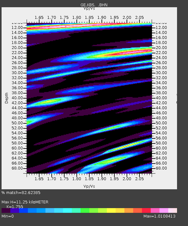
| Estimated Moho Depth: |
11.25 km |
| Estimated Crust Vp/Vs: |
1.75 |
| Assumed Crust Vp: |
6.287 km/s |
| Estimated Crust Vs: |
3.583 km/s |
| Estimated Crust Poisson's Ratio: |
0.26 |
|
| Radial Match: |
82.62385 % |
| Radial Bump: |
400 |
| Transverse Match: |
71.12733 % |
| Transverse Bump: |
400 |
| SOD ConfigId: |
6273 |
| Insert Time: |
2010-03-09 05:00:43.670 +0000 |
| GWidth: |
2.5 |
| Max Bumps: |
400 |
| Tol: |
0.001 |
|

Signal To Noise
| Channel | StoN | STA | LTA |
| GE:KBS: :BHN:19961001T16:01:04.514001Z | 1.2032492 | 1.4476119E-7 | 1.2030857E-7 |
| GE:KBS: :BHE:19961001T16:01:04.514001Z | 2.4539664 | 2.391268E-7 | 9.744501E-8 |
| GE:KBS: :BHZ:19961001T16:01:04.514001Z | 1.3940012 | 2.7046093E-7 | 1.940177E-7 |
| Arrivals |
| Ps | 1.4 SECOND |
| PpPs | 4.8 SECOND |
| PsPs/PpSs | 6.2 SECOND |


