You are here: Home > Network List > XW97 - Tien Shan Continental Dynamics Stations List
> Station ANA XW.ANA > Earthquake Result Viewer
ANA XW.ANA - Earthquake Result Viewer
| Earthquake location: |
Minahassa Peninsula, Sulawesi |
| Earthquake latitude/longitude: |
0.1/123.5 |
| Earthquake time(UTC): |
1999/06/02 (153) 00:23:19 GMT |
| Earthquake Depth: |
161 km |
| Earthquake Magnitude: |
5.8 MB, 5.6 MW |
| Earthquake Catalog/Contributor: |
WHDF/NEIC |
|
| Network: |
XW Tien Shan Continental Dynamics |
| Station: |
ANA XW.ANA |
| Lat/Lon: |
42.78 N/77.66 E |
| Elevation: |
1813 m |
|
| Distance: |
59.1 deg |
| Az: |
322.019 deg |
| Baz: |
123.288 deg |
| Ray Param: |
0.061906945 |
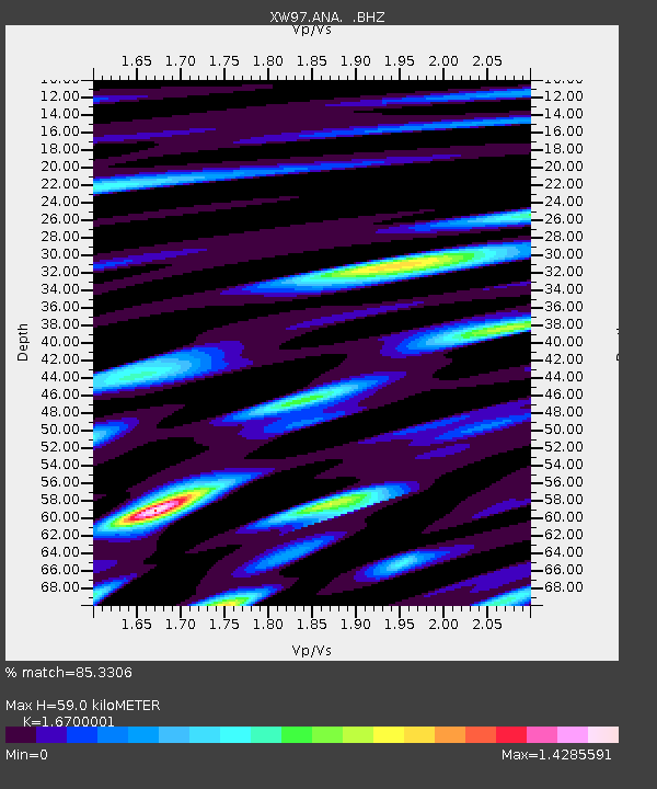
| Estimated Moho Depth: |
59.0 km |
| Estimated Crust Vp/Vs: |
1.67 |
| Assumed Crust Vp: |
6.306 km/s |
| Estimated Crust Vs: |
3.776 km/s |
| Estimated Crust Poisson's Ratio: |
0.22 |
|
| Radial Match: |
85.3306 % |
| Radial Bump: |
400 |
| Transverse Match: |
80.44419 % |
| Transverse Bump: |
400 |
| SOD ConfigId: |
4480 |
| Insert Time: |
2010-02-26 15:16:27.353 +0000 |
| GWidth: |
2.5 |
| Max Bumps: |
400 |
| Tol: |
0.001 |
|
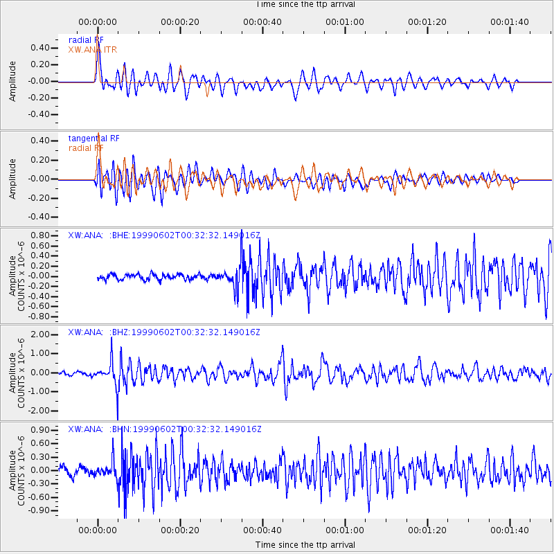
Signal To Noise
| Channel | StoN | STA | LTA |
| XW:ANA: :BHZ:19990602T00:32:32.149016Z | 8.881724 | 6.265532E-7 | 7.054409E-8 |
| XW:ANA: :BHN:19990602T00:32:32.149016Z | 2.4502046 | 1.8551908E-7 | 7.5715754E-8 |
| XW:ANA: :BHE:19990602T00:32:32.149016Z | 4.0767817 | 2.1875714E-7 | 5.3659274E-8 |
| Arrivals |
| Ps | 6.6 SECOND |
| PpPs | 24 SECOND |
| PsPs/PpSs | 30 SECOND |


