You are here: Home > Network List > GE - GEOFON Stations List
> Station KBS IRIS/GEOFON/AWI Station Ny Alesund, Spitsbergen > Earthquake Result Viewer
KBS IRIS/GEOFON/AWI Station Ny Alesund, Spitsbergen - Earthquake Result Viewer
| Earthquake location: |
Samar, Philippines |
| Earthquake latitude/longitude: |
11.8/125.5 |
| Earthquake time(UTC): |
1996/10/02 (276) 09:48:01 GMT |
| Earthquake Depth: |
33 km |
| Earthquake Magnitude: |
6.0 MB, 6.4 MS, 6.4 UNKNOWN, 6.3 MW |
| Earthquake Catalog/Contributor: |
WHDF/NEIC |
|
| Network: |
GE GEOFON |
| Station: |
KBS IRIS/GEOFON/AWI Station Ny Alesund, Spitsbergen |
| Lat/Lon: |
78.93 N/11.94 E |
| Elevation: |
77 m |
|
| Distance: |
82.9 deg |
| Az: |
349.712 deg |
| Baz: |
64.776 deg |
| Ray Param: |
0.046501756 |
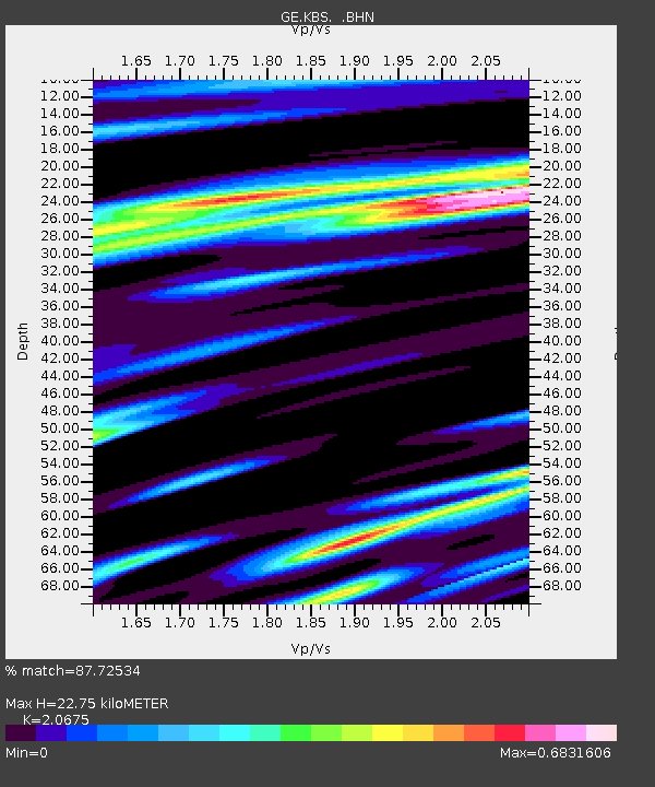
| Estimated Moho Depth: |
22.75 km |
| Estimated Crust Vp/Vs: |
2.07 |
| Assumed Crust Vp: |
6.287 km/s |
| Estimated Crust Vs: |
3.041 km/s |
| Estimated Crust Poisson's Ratio: |
0.35 |
|
| Radial Match: |
87.72534 % |
| Radial Bump: |
400 |
| Transverse Match: |
78.39613 % |
| Transverse Bump: |
400 |
| SOD ConfigId: |
6273 |
| Insert Time: |
2010-03-09 05:00:44.817 +0000 |
| GWidth: |
2.5 |
| Max Bumps: |
400 |
| Tol: |
0.001 |
|

Signal To Noise
| Channel | StoN | STA | LTA |
| GE:KBS: :BHN:19961002T09:59:51.864014Z | 1.1580185 | 8.3686544E-8 | 7.226702E-8 |
| GE:KBS: :BHE:19961002T09:59:51.864014Z | 3.074858 | 1.935509E-7 | 6.294629E-8 |
| GE:KBS: :BHZ:19961002T09:59:51.864014Z | 6.797726 | 6.189901E-7 | 9.10584E-8 |
| Arrivals |
| Ps | 3.9 SECOND |
| PpPs | 11 SECOND |
| PsPs/PpSs | 15 SECOND |


