You are here: Home > Network List > CN - Canadian National Seismograph Network Stations List
> Station BRWY Burwash Landing, YT, CA > Earthquake Result Viewer
BRWY Burwash Landing, YT, CA - Earthquake Result Viewer
| Earthquake location: |
Philippine Islands Region |
| Earthquake latitude/longitude: |
5.0/127.5 |
| Earthquake time(UTC): |
2021/01/21 (021) 12:23:05 GMT |
| Earthquake Depth: |
96 km |
| Earthquake Magnitude: |
7.0 mww |
| Earthquake Catalog/Contributor: |
NEIC PDE/us |
|
| Network: |
CN Canadian National Seismograph Network |
| Station: |
BRWY Burwash Landing, YT, CA |
| Lat/Lon: |
61.37 N/139.03 W |
| Elevation: |
802 m |
|
| Distance: |
87.3 deg |
| Az: |
28.77 deg |
| Baz: |
275.416 deg |
| Ray Param: |
0.043231938 |
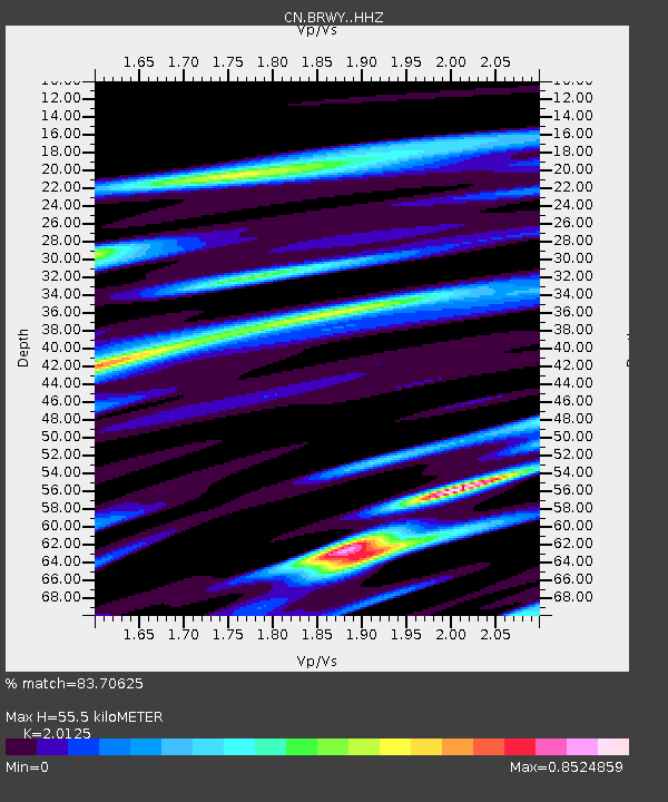
| Estimated Moho Depth: |
55.5 km |
| Estimated Crust Vp/Vs: |
2.01 |
| Assumed Crust Vp: |
6.566 km/s |
| Estimated Crust Vs: |
3.263 km/s |
| Estimated Crust Poisson's Ratio: |
0.34 |
|
| Radial Match: |
83.70625 % |
| Radial Bump: |
400 |
| Transverse Match: |
70.06525 % |
| Transverse Bump: |
400 |
| SOD ConfigId: |
23341671 |
| Insert Time: |
2021-02-04 13:31:31.729 +0000 |
| GWidth: |
2.5 |
| Max Bumps: |
400 |
| Tol: |
0.001 |
|

Signal To Noise
| Channel | StoN | STA | LTA |
| CN:BRWY: :HHZ:20210121T12:35:10.649977Z | 6.9827886 | 3.2276128E-6 | 4.6222402E-7 |
| CN:BRWY: :HHN:20210121T12:35:10.649977Z | 1.0934848 | 5.525036E-7 | 5.052687E-7 |
| CN:BRWY: :HHE:20210121T12:35:10.649977Z | 2.112151 | 1.0727588E-6 | 5.0789873E-7 |
| Arrivals |
| Ps | 8.7 SECOND |
| PpPs | 25 SECOND |
| PsPs/PpSs | 34 SECOND |


