You are here: Home > Network List > G - GEOSCOPE Stations List
> Station CAN Canberra, Australia > Earthquake Result Viewer
CAN Canberra, Australia - Earthquake Result Viewer
| Earthquake location: |
Philippine Islands Region |
| Earthquake latitude/longitude: |
5.0/127.5 |
| Earthquake time(UTC): |
2021/01/21 (021) 12:23:05 GMT |
| Earthquake Depth: |
96 km |
| Earthquake Magnitude: |
7.0 mww |
| Earthquake Catalog/Contributor: |
NEIC PDE/us |
|
| Network: |
G GEOSCOPE |
| Station: |
CAN Canberra, Australia |
| Lat/Lon: |
35.32 S/149.00 E |
| Elevation: |
650 m |
|
| Distance: |
44.9 deg |
| Az: |
154.903 deg |
| Baz: |
328.887 deg |
| Ray Param: |
0.071297966 |
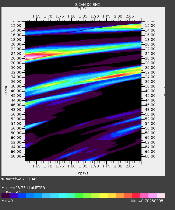
| Estimated Moho Depth: |
25.75 km |
| Estimated Crust Vp/Vs: |
1.61 |
| Assumed Crust Vp: |
6.633 km/s |
| Estimated Crust Vs: |
4.133 km/s |
| Estimated Crust Poisson's Ratio: |
0.18 |
|
| Radial Match: |
97.21349 % |
| Radial Bump: |
347 |
| Transverse Match: |
88.00607 % |
| Transverse Bump: |
400 |
| SOD ConfigId: |
23341671 |
| Insert Time: |
2021-02-04 13:32:35.262 +0000 |
| GWidth: |
2.5 |
| Max Bumps: |
400 |
| Tol: |
0.001 |
|

Signal To Noise
| Channel | StoN | STA | LTA |
| G:CAN:00:BHZ:20210121T12:30:40.448988Z | 21.952263 | 8.634876E-6 | 3.9334788E-7 |
| G:CAN:00:BHN:20210121T12:30:40.448988Z | 14.753112 | 4.310619E-6 | 2.921837E-7 |
| G:CAN:00:BHE:20210121T12:30:40.448988Z | 6.0319276 | 2.1413232E-6 | 3.5499818E-7 |
| Arrivals |
| Ps | 2.5 SECOND |
| PpPs | 9.4 SECOND |
| PsPs/PpSs | 12 SECOND |


