You are here: Home > Network List > G - GEOSCOPE Stations List
> Station CRZF Port Alfred, Crozet, South Indian Ocean > Earthquake Result Viewer
CRZF Port Alfred, Crozet, South Indian Ocean - Earthquake Result Viewer
| Earthquake location: |
Philippine Islands Region |
| Earthquake latitude/longitude: |
5.0/127.5 |
| Earthquake time(UTC): |
2021/01/21 (021) 12:23:05 GMT |
| Earthquake Depth: |
96 km |
| Earthquake Magnitude: |
7.0 mww |
| Earthquake Catalog/Contributor: |
NEIC PDE/us |
|
| Network: |
G GEOSCOPE |
| Station: |
CRZF Port Alfred, Crozet, South Indian Ocean |
| Lat/Lon: |
46.43 S/51.86 E |
| Elevation: |
140 m |
|
| Distance: |
83.8 deg |
| Az: |
222.381 deg |
| Baz: |
76.136 deg |
| Ray Param: |
0.04573268 |
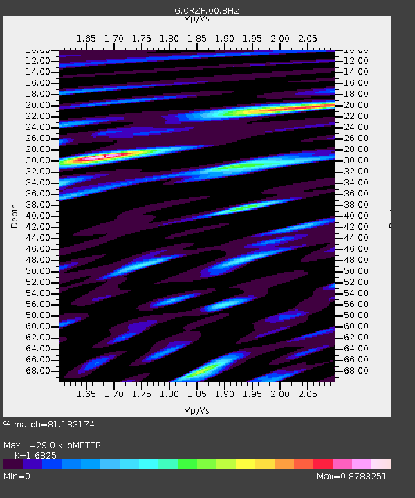
| Estimated Moho Depth: |
29.0 km |
| Estimated Crust Vp/Vs: |
1.68 |
| Assumed Crust Vp: |
4.802 km/s |
| Estimated Crust Vs: |
2.854 km/s |
| Estimated Crust Poisson's Ratio: |
0.23 |
|
| Radial Match: |
81.183174 % |
| Radial Bump: |
400 |
| Transverse Match: |
62.599846 % |
| Transverse Bump: |
400 |
| SOD ConfigId: |
23341671 |
| Insert Time: |
2021-02-04 13:32:38.028 +0000 |
| GWidth: |
2.5 |
| Max Bumps: |
400 |
| Tol: |
0.001 |
|
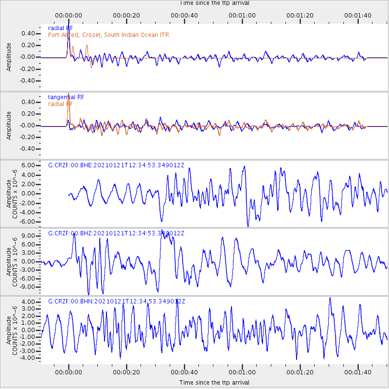
Signal To Noise
| Channel | StoN | STA | LTA |
| G:CRZF:00:BHZ:20210121T12:34:53.349012Z | 4.921834 | 4.2754114E-6 | 8.6866226E-7 |
| G:CRZF:00:BHN:20210121T12:34:53.349012Z | 1.1255661 | 1.8503388E-6 | 1.6439184E-6 |
| G:CRZF:00:BHE:20210121T12:34:53.349012Z | 1.9656236 | 2.692703E-6 | 1.3698975E-6 |
| Arrivals |
| Ps | 4.2 SECOND |
| PpPs | 16 SECOND |
| PsPs/PpSs | 20 SECOND |


