You are here: Home > Network List > GE - GEOFON Stations List
> Station KBS IRIS/GEOFON/AWI Station Ny Alesund, Spitsbergen > Earthquake Result Viewer
KBS IRIS/GEOFON/AWI Station Ny Alesund, Spitsbergen - Earthquake Result Viewer
| Earthquake location: |
Off East Coast Of Kamchatka |
| Earthquake latitude/longitude: |
52.2/159.5 |
| Earthquake time(UTC): |
1998/05/27 (147) 20:41:37 GMT |
| Earthquake Depth: |
60 km |
| Earthquake Magnitude: |
5.5 MB, 6.0 UNKNOWN, 5.9 MW |
| Earthquake Catalog/Contributor: |
WHDF/NEIC |
|
| Network: |
GE GEOFON |
| Station: |
KBS IRIS/GEOFON/AWI Station Ny Alesund, Spitsbergen |
| Lat/Lon: |
78.93 N/11.94 E |
| Elevation: |
77 m |
|
| Distance: |
47.7 deg |
| Az: |
351.942 deg |
| Baz: |
26.479 deg |
| Ray Param: |
0.06967409 |
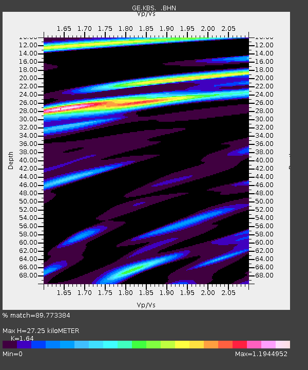
| Estimated Moho Depth: |
27.25 km |
| Estimated Crust Vp/Vs: |
1.64 |
| Assumed Crust Vp: |
6.287 km/s |
| Estimated Crust Vs: |
3.834 km/s |
| Estimated Crust Poisson's Ratio: |
0.20 |
|
| Radial Match: |
89.773384 % |
| Radial Bump: |
400 |
| Transverse Match: |
71.83723 % |
| Transverse Bump: |
400 |
| SOD ConfigId: |
4480 |
| Insert Time: |
2010-03-09 05:00:59.997 +0000 |
| GWidth: |
2.5 |
| Max Bumps: |
400 |
| Tol: |
0.001 |
|

Signal To Noise
| Channel | StoN | STA | LTA |
| GE:KBS: :BHN:19980527T20:49:37.828009Z | 29.245592 | 1.381787E-6 | 4.7247703E-8 |
| GE:KBS: :BHE:19980527T20:49:37.828009Z | 17.99095 | 6.165021E-7 | 3.4267348E-8 |
| GE:KBS: :BHZ:19980527T20:49:37.828009Z | 9.244047 | 3.392396E-7 | 3.6698168E-8 |
| Arrivals |
| Ps | 3.0 SECOND |
| PpPs | 11 SECOND |
| PsPs/PpSs | 14 SECOND |


