You are here: Home > Network List > GE - GEOFON Stations List
> Station KBS IRIS/GEOFON/AWI Station Ny Alesund, Spitsbergen > Earthquake Result Viewer
KBS IRIS/GEOFON/AWI Station Ny Alesund, Spitsbergen - Earthquake Result Viewer
| Earthquake location: |
Southern Alaska |
| Earthquake latitude/longitude: |
60.5/-153.2 |
| Earthquake time(UTC): |
1998/07/09 (190) 19:39:43 GMT |
| Earthquake Depth: |
145 km |
| Earthquake Magnitude: |
5.3 MB, 6.2 UNKNOWN, 6.2 MW |
| Earthquake Catalog/Contributor: |
WHDF/NEIC |
|
| Network: |
GE GEOFON |
| Station: |
KBS IRIS/GEOFON/AWI Station Ny Alesund, Spitsbergen |
| Lat/Lon: |
78.93 N/11.94 E |
| Elevation: |
77 m |
|
| Distance: |
40.5 deg |
| Az: |
4.372 deg |
| Baz: |
348.756 deg |
| Ray Param: |
0.0738297 |
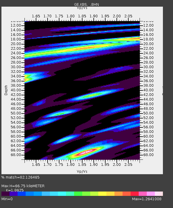
| Estimated Moho Depth: |
66.75 km |
| Estimated Crust Vp/Vs: |
1.86 |
| Assumed Crust Vp: |
6.287 km/s |
| Estimated Crust Vs: |
3.376 km/s |
| Estimated Crust Poisson's Ratio: |
0.30 |
|
| Radial Match: |
82.126465 % |
| Radial Bump: |
400 |
| Transverse Match: |
69.888664 % |
| Transverse Bump: |
400 |
| SOD ConfigId: |
4480 |
| Insert Time: |
2010-03-09 05:01:07.379 +0000 |
| GWidth: |
2.5 |
| Max Bumps: |
400 |
| Tol: |
0.001 |
|

Signal To Noise
| Channel | StoN | STA | LTA |
| GE:KBS: :BHN:19980709T19:46:38.177008Z | 3.4197192 | 3.0773407E-7 | 8.998811E-8 |
| GE:KBS: :BHE:19980709T19:46:38.177008Z | 1.377852 | 1.2707605E-7 | 9.222766E-8 |
| GE:KBS: :BHZ:19980709T19:46:38.177008Z | 0.8953027 | 1.0604419E-7 | 1.1844507E-7 |
| Arrivals |
| Ps | 9.7 SECOND |
| PpPs | 29 SECOND |
| PsPs/PpSs | 38 SECOND |


