You are here: Home > Network List > II - Global Seismograph Network (GSN - IRIS/IDA) Stations List
> Station KURK Kurchatov, Kazakhstan > Earthquake Result Viewer
KURK Kurchatov, Kazakhstan - Earthquake Result Viewer
| Earthquake location: |
Philippine Islands Region |
| Earthquake latitude/longitude: |
5.0/127.5 |
| Earthquake time(UTC): |
2021/01/21 (021) 12:23:05 GMT |
| Earthquake Depth: |
96 km |
| Earthquake Magnitude: |
7.0 mww |
| Earthquake Catalog/Contributor: |
NEIC PDE/us |
|
| Network: |
II Global Seismograph Network (GSN - IRIS/IDA) |
| Station: |
KURK Kurchatov, Kazakhstan |
| Lat/Lon: |
50.72 N/78.62 E |
| Elevation: |
184 m |
|
| Distance: |
61.1 deg |
| Az: |
326.826 deg |
| Baz: |
120.965 deg |
| Ray Param: |
0.060827725 |
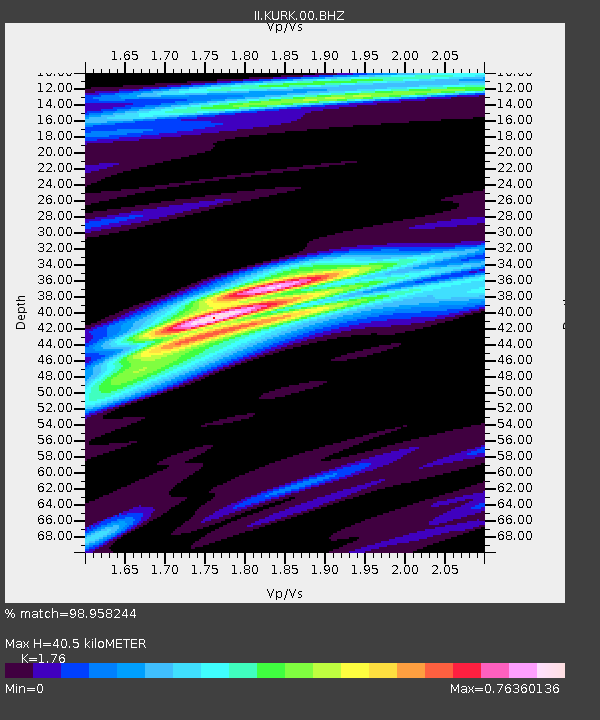
| Estimated Moho Depth: |
40.5 km |
| Estimated Crust Vp/Vs: |
1.76 |
| Assumed Crust Vp: |
6.552 km/s |
| Estimated Crust Vs: |
3.723 km/s |
| Estimated Crust Poisson's Ratio: |
0.26 |
|
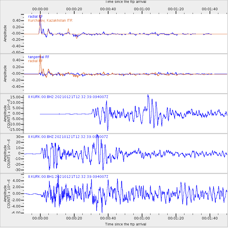
| Radial Match: |
98.958244 % |
| Radial Bump: |
234 |
| Transverse Match: |
95.3009 % |
| Transverse Bump: |
400 |
| SOD ConfigId: |
23341671 |
| Insert Time: |
2021-02-04 13:33:41.535 +0000 |
| GWidth: |
2.5 |
| Max Bumps: |
400 |
| Tol: |
0.001 |
|
Signal To Noise
| Channel | StoN | STA | LTA |
| II:KURK:00:BHZ:20210121T12:32:39.094007Z | 60.342552 | 7.020924E-6 | 1.16351124E-7 |
| II:KURK:00:BH1:20210121T12:32:39.094007Z | 7.203933 | 8.3174143E-7 | 1.1545658E-7 |
| II:KURK:00:BH2:20210121T12:32:39.094007Z | 23.268457 | 2.761797E-6 | 1.18692746E-7 |
| Arrivals |
| Ps | 4.9 SECOND |
| PpPs | 16 SECOND |
| PsPs/PpSs | 21 SECOND |


