You are here: Home > Network List > IU - Global Seismograph Network (GSN - IRIS/USGS) Stations List
> Station JOHN Johnston Island, USA > Earthquake Result Viewer
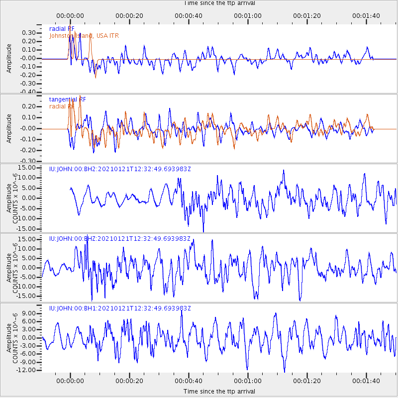
JOHN Johnston Island, USA - Earthquake Result Viewer
*The percent match for this event was below the threshold and hence no stack was calculated.
| Earthquake location: |
Philippine Islands Region |
| Earthquake latitude/longitude: |
5.0/127.5 |
| Earthquake time(UTC): |
2021/01/21 (021) 12:23:05 GMT |
| Earthquake Depth: |
96 km |
| Earthquake Magnitude: |
7.0 mww |
| Earthquake Catalog/Contributor: |
NEIC PDE/us |
|
| Network: |
IU Global Seismograph Network (GSN - IRIS/USGS) |
| Station: |
JOHN Johnston Island, USA |
| Lat/Lon: |
16.73 N/169.53 W |
| Elevation: |
2.0 m |
|
| Distance: |
62.7 deg |
| Az: |
73.84 deg |
| Baz: |
266.997 deg |
| Ray Param: |
$rayparam |
*The percent match for this event was below the threshold and hence was not used in the summary stack. |
|
| Radial Match: |
51.170635 % |
| Radial Bump: |
400 |
| Transverse Match: |
57.301563 % |
| Transverse Bump: |
400 |
| SOD ConfigId: |
23341671 |
| Insert Time: |
2021-02-04 13:34:11.872 +0000 |
| GWidth: |
2.5 |
| Max Bumps: |
400 |
| Tol: |
0.001 |
|
Signal To Noise
| Channel | StoN | STA | LTA |
| IU:JOHN:00:BHZ:20210121T12:32:49.693983Z | 1.9306716 | 5.5346154E-6 | 2.8666789E-6 |
| IU:JOHN:00:BH1:20210121T12:32:49.693983Z | 1.0434035 | 2.414925E-6 | 2.314469E-6 |
| IU:JOHN:00:BH2:20210121T12:32:49.693983Z | 1.4323996 | 4.0672944E-6 | 2.8394968E-6 |
| Arrivals |
| Ps | |
| PpPs | |
| PsPs/PpSs | |


