You are here: Home > Network List > KG - Korean Seismic Network- KIGAM Stations List
> Station TJN Taejon, Republic of Korea > Earthquake Result Viewer
TJN Taejon, Republic of Korea - Earthquake Result Viewer
| Earthquake location: |
Philippine Islands Region |
| Earthquake latitude/longitude: |
5.0/127.5 |
| Earthquake time(UTC): |
2021/01/21 (021) 12:23:05 GMT |
| Earthquake Depth: |
96 km |
| Earthquake Magnitude: |
7.0 mww |
| Earthquake Catalog/Contributor: |
NEIC PDE/us |
|
| Network: |
KG Korean Seismic Network- KIGAM |
| Station: |
TJN Taejon, Republic of Korea |
| Lat/Lon: |
36.38 N/127.36 E |
| Elevation: |
60 m |
|
| Distance: |
31.2 deg |
| Az: |
359.761 deg |
| Baz: |
179.705 deg |
| Ray Param: |
0.07893168 |
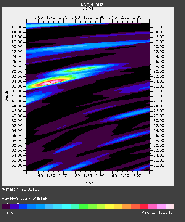
| Estimated Moho Depth: |
34.25 km |
| Estimated Crust Vp/Vs: |
1.70 |
| Assumed Crust Vp: |
6.459 km/s |
| Estimated Crust Vs: |
3.805 km/s |
| Estimated Crust Poisson's Ratio: |
0.23 |
|
| Radial Match: |
96.32125 % |
| Radial Bump: |
344 |
| Transverse Match: |
75.623505 % |
| Transverse Bump: |
400 |
| SOD ConfigId: |
23341671 |
| Insert Time: |
2021-02-04 13:34:39.005 +0000 |
| GWidth: |
2.5 |
| Max Bumps: |
400 |
| Tol: |
0.001 |
|

Signal To Noise
| Channel | StoN | STA | LTA |
| KG:TJN: :BHZ:20210121T12:28:45.918989Z | 27.849619 | 1.6345444E-5 | 5.869181E-7 |
| KG:TJN: :BHN:20210121T12:28:45.918989Z | 21.545002 | 1.0155342E-5 | 4.713549E-7 |
| KG:TJN: :BHE:20210121T12:28:45.918989Z | 2.5363855 | 1.1444168E-6 | 4.5119987E-7 |
| Arrivals |
| Ps | 4.0 SECOND |
| PpPs | 13 SECOND |
| PsPs/PpSs | 17 SECOND |


