You are here: Home > Network List > MM - Myanmar National Seismic Network Stations List
> Station TMU Tamu, Sagaing, Myanmar > Earthquake Result Viewer
TMU Tamu, Sagaing, Myanmar - Earthquake Result Viewer
| Earthquake location: |
Philippine Islands Region |
| Earthquake latitude/longitude: |
5.0/127.5 |
| Earthquake time(UTC): |
2021/01/21 (021) 12:23:05 GMT |
| Earthquake Depth: |
96 km |
| Earthquake Magnitude: |
7.0 mww |
| Earthquake Catalog/Contributor: |
NEIC PDE/us |
|
| Network: |
MM Myanmar National Seismic Network |
| Station: |
TMU Tamu, Sagaing, Myanmar |
| Lat/Lon: |
24.23 N/94.30 E |
| Elevation: |
182 m |
|
| Distance: |
37.2 deg |
| Az: |
304.237 deg |
| Baz: |
115.557 deg |
| Ray Param: |
0.075946614 |
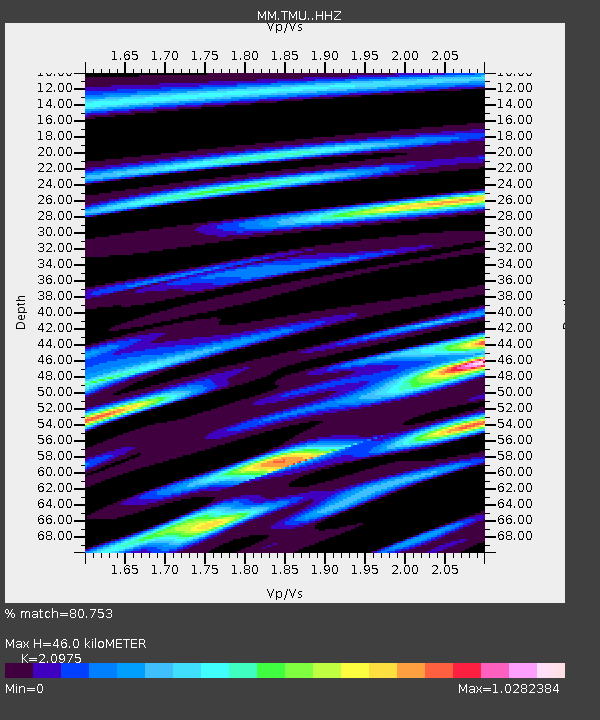
| Estimated Moho Depth: |
46.0 km |
| Estimated Crust Vp/Vs: |
2.10 |
| Assumed Crust Vp: |
6.316 km/s |
| Estimated Crust Vs: |
3.011 km/s |
| Estimated Crust Poisson's Ratio: |
0.35 |
|
| Radial Match: |
80.753 % |
| Radial Bump: |
400 |
| Transverse Match: |
67.60489 % |
| Transverse Bump: |
400 |
| SOD ConfigId: |
23341671 |
| Insert Time: |
2021-02-04 13:35:30.556 +0000 |
| GWidth: |
2.5 |
| Max Bumps: |
400 |
| Tol: |
0.001 |
|

Signal To Noise
| Channel | StoN | STA | LTA |
| MM:TMU: :HHZ:20210121T12:29:37.587995Z | 34.642868 | 3.9718157E-6 | 1.1465031E-7 |
| MM:TMU: :HHN:20210121T12:29:37.587995Z | 15.545846 | 1.2843044E-6 | 8.2613994E-8 |
| MM:TMU: :HHE:20210121T12:29:37.587995Z | 16.03242 | 1.5624825E-6 | 9.745768E-8 |
| Arrivals |
| Ps | 8.5 SECOND |
| PpPs | 21 SECOND |
| PsPs/PpSs | 30 SECOND |


