You are here: Home > Network List > MM - Myanmar National Seismic Network Stations List
> Station YGN Yangon, Yangon, Myanmar > Earthquake Result Viewer
YGN Yangon, Yangon, Myanmar - Earthquake Result Viewer
| Earthquake location: |
Philippine Islands Region |
| Earthquake latitude/longitude: |
5.0/127.5 |
| Earthquake time(UTC): |
2021/01/21 (021) 12:23:05 GMT |
| Earthquake Depth: |
96 km |
| Earthquake Magnitude: |
7.0 mww |
| Earthquake Catalog/Contributor: |
NEIC PDE/us |
|
| Network: |
MM Myanmar National Seismic Network |
| Station: |
YGN Yangon, Yangon, Myanmar |
| Lat/Lon: |
16.86 N/96.15 E |
| Elevation: |
20 m |
|
| Distance: |
32.9 deg |
| Az: |
293.467 deg |
| Baz: |
107.376 deg |
| Ray Param: |
0.07819981 |
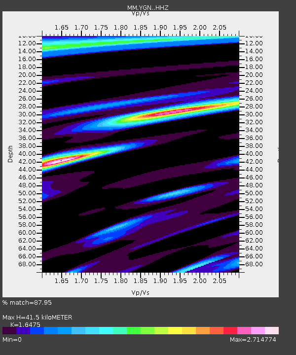
| Estimated Moho Depth: |
41.5 km |
| Estimated Crust Vp/Vs: |
1.65 |
| Assumed Crust Vp: |
6.287 km/s |
| Estimated Crust Vs: |
3.816 km/s |
| Estimated Crust Poisson's Ratio: |
0.21 |
|
| Radial Match: |
87.95 % |
| Radial Bump: |
400 |
| Transverse Match: |
78.79877 % |
| Transverse Bump: |
400 |
| SOD ConfigId: |
23341671 |
| Insert Time: |
2021-02-04 13:35:32.379 +0000 |
| GWidth: |
2.5 |
| Max Bumps: |
400 |
| Tol: |
0.001 |
|

Signal To Noise
| Channel | StoN | STA | LTA |
| MM:YGN: :HHZ:20210121T12:29:00.628004Z | 5.106239 | 8.963477E-6 | 1.7553971E-6 |
| MM:YGN: :HHN:20210121T12:29:00.628004Z | 1.2005534 | 2.5007987E-6 | 2.0830385E-6 |
| MM:YGN: :HHE:20210121T12:29:00.628004Z | 1.6858255 | 3.8059209E-6 | 2.2576007E-6 |
| Arrivals |
| Ps | 4.6 SECOND |
| PpPs | 16 SECOND |
| PsPs/PpSs | 21 SECOND |


