You are here: Home > Network List > PF - Volcanologic Network of Piton de Fournaise-OVPF Stations List
> Station GPS Grandes Pentes Sud > Earthquake Result Viewer
GPS Grandes Pentes Sud - Earthquake Result Viewer
| Earthquake location: |
Philippine Islands Region |
| Earthquake latitude/longitude: |
5.0/127.5 |
| Earthquake time(UTC): |
2021/01/21 (021) 12:23:05 GMT |
| Earthquake Depth: |
96 km |
| Earthquake Magnitude: |
7.0 mww |
| Earthquake Catalog/Contributor: |
NEIC PDE/us |
|
| Network: |
PF Volcanologic Network of Piton de Fournaise-OVPF |
| Station: |
GPS Grandes Pentes Sud |
| Lat/Lon: |
21.27 S/55.76 E |
| Elevation: |
1004 m |
|
| Distance: |
75.0 deg |
| Az: |
246.533 deg |
| Baz: |
78.451 deg |
| Ray Param: |
0.051773492 |
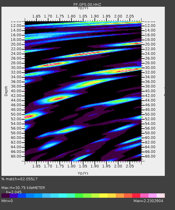
| Estimated Moho Depth: |
30.75 km |
| Estimated Crust Vp/Vs: |
2.05 |
| Assumed Crust Vp: |
4.73 km/s |
| Estimated Crust Vs: |
2.313 km/s |
| Estimated Crust Poisson's Ratio: |
0.34 |
|
| Radial Match: |
82.05517 % |
| Radial Bump: |
400 |
| Transverse Match: |
60.24237 % |
| Transverse Bump: |
400 |
| SOD ConfigId: |
23341671 |
| Insert Time: |
2021-02-04 13:36:00.579 +0000 |
| GWidth: |
2.5 |
| Max Bumps: |
400 |
| Tol: |
0.001 |
|
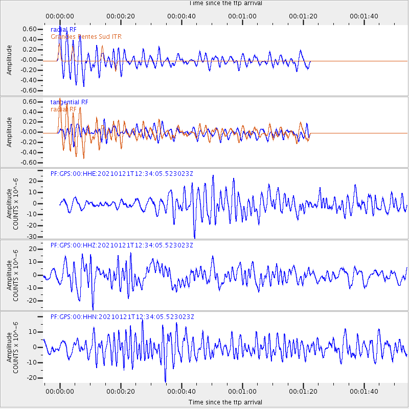
Signal To Noise
| Channel | StoN | STA | LTA |
| PF:GPS:00:HHZ:20210121T12:34:05.523023Z | 4.599096 | 7.3521524E-6 | 1.5986082E-6 |
| PF:GPS:00:HHN:20210121T12:34:05.523023Z | 1.0891169 | 3.8415246E-6 | 3.527192E-6 |
| PF:GPS:00:HHE:20210121T12:34:05.523023Z | 1.8435463 | 5.160196E-6 | 2.7990595E-6 |
| Arrivals |
| Ps | 6.9 SECOND |
| PpPs | 20 SECOND |
| PsPs/PpSs | 26 SECOND |


